


49th Avenue Corridor
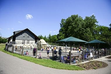
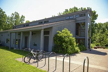
Carl W. Kroening Nature Center
North Mississippi Regional Trail
5116 North Mississippi Drive
Minneapolis, MN 55412
Phone: 612-230-6400
Email: info@minneapolisparks.org
6 am-midnight in developed areas
6 am-10 pm in undeveloped areas
Ordinance PB-2-33
The Camden boat launch at North Mississippi Regional Park, is closed until 2026 for the Olson Island Mussel Habitat Protection project. Click here to learn more at about the project.
Monday-Friday: 9 am-4 pm
Saturday: 10 am-4 pm
Closed Sunday
Not finding what you’re looking for?
Search Parks & Destinations
Rent a kayak via paddleshare.org.
Playful plant signs (see Gallery below) by artist Lily Crawford line the path between the Nature Center and playground/wading pool.
This park will be affected by a park improvement project. View North Mississippi Regional Park Plan.

The Center offers a host of activities and programs connecting people to North Mississippi Regional Park, including the permanent “Nature in the City” exhibition.
Size: 67.2 acres
Neighborhood: Camden, Camden Industrial, Lind-Bohanon and Webber
Service Area: North
Athletic Rentals: To reserve a field, court, or rink visit our athletic permit page.
Food Truck Permit: City of Minneapolis licensed food truck operators can apply for a one-day permit at this park. View food truck permit details.
Outdoor Use and Event Space: Learn how to reserve park space for corporate events, community celebrations, and more.
Picnics: Reserve a picnic site for your upcoming birthday party, reunion, company picnic, or other special event. View picnic permit details.
Name: The name is descriptive of the park on the west bank of the Mississippi River in north Minneapolis.
Acquisition and Development
This section of the Mississippi River received the attention of the park board long before land was acquired for a park. In 1891 in an influential report on the possible expansion of the Minneapolis park system, park commissioner William Folwell, former president of the University of Minnesota, proposed that the park board acquire the banks on both sides of the river upstream from the Camden pumping station to protect the city’s water supply. While that was at the time beyond the means of the park board, it was one of the first suggestions for acquiring property along the river upstream from St. Anthony Falls and Nicollet Island. In fact that report preceded the acquisition of the river banks downstream from the falls.
When the park board began acquiring land rapidly in the early 1900s after years of limited resources, it acquired land near the site of North Mississippi Park. In 1908 the board purchased the land for Camden (Webber) Park along Shingle Creek a few hundred yards upstream from the creek’s mouth at the Mississippi. Although Camden Park and its fresh-water swimming pool fed by Shingle Creek were very popular, the park lacked space for athletic fields.
In 1917 the park board voted to address that shortcoming by acquiring the land between Lyndale Avenue North and the river to enlarge the park. Park superintendent Theodore Wirth presented a plan for the enlargement of the park in September 1917 (reproduced in the 1917 annual report), which included the provision of baseball and football fields that Camden Park could not accommodate. Wirth noted that the former lumber yard would need a covering of clay soil to be useable. He also proposed a small shelter and a drive to the river with a small parking lot. Wirth presented a revised plan at half the cost that November, still providing primarily athletic fields for the expanded park. The revised plan must have met with neighborhood approval because two weeks later the Camden Commercial Club petitioned for the expansion of Camden Park to the river as far north as 50th Street and for proposed improvements to the new land and to the existing Camden Park.
However, about the same time the North Side Commercial Club asked the board to curtail all new acquisitions and improvements. As World War I dragged into 1918 the park board canceled many plans for enlarging and improving parks, and the expansion of Camden Park was no exception. In March 1918, the board deferred action on the new park. Later that year the park board did give public notice that it planned to acquire one acre of land at 42nd and the river “at the proper time.” The action was taken, at the request of many area civic groups, to forestall the creation of a coal yard on the site. The board reported that “if conditions were normal” it would not hesitate to acquire the land, but under “present conditions” could only state its intent to acquire the land in the future.
That intent, manifested by several later attempts to acquire the land, persisted. The park board began proceedings again in 1919 and 1922 to acquire the land, but abandoned them. In 1929 Wirth finally proposed adding a ball field to Camden Park on land that was part of the Glenwood-Camden Parkway, and suggested that residents of the area were able and willing to be assessed the cost of the improvements.
Over the next decade the target of park board interest in the area was in improving the grounds of the city’s old water pumping station, which was no longer used. By 1940 another problem had arisen. The land below the 42nd Avenue Bridge was occupied by “squatters and house trailers.” The park board offered to improve the land if the city would clear the land of its temporary residents and appropriate money to maintain the park. The city council declined that offer.
Finally in 1944 the park board was informed that the state might sell the tax delinquent land it had acquired from 48th to 49th on the river and asked the state to inform the board of any land for sale so the board could determine if that land fit into the board’s plans. (The park board acquired the land for Bossen Field and Hi-View Park free from the state under those terms.)
The city did request that the state withhold from sale all land along the river in 1946. The city wanted the land from 42nd Avenue to downtown for an upper harbor and the land north could be used as a park. In the 1946 annual report park superintendent Charles Doell reported that the park board was considering acquiring 98 acres of land along the river from 42nd to 51st Streets, 75 percent of which was owned by the state as tax-delinquent land. Doell noted that Liebert Weir in his 1944 study of the Minneapolis park system had recommended that the park board acquire the river banks along that section of the river. However, Doell noted that there were objections to the acquisition which prevented the park board from including the land in its requests for bond funding. Doell added that the state highway department had made preliminary plans to use part of the area for highway purposes. This would be the issue that would eventually determine the boundaries of today’s North Mississippi Park.
In 1950 the park board initiated condemnation proceedings to acquire much of the land between 44th Street and 47th Street from Lyndale Avenue North to the river—twenty acres at a cost of $15,000 for acquisition and improvement—but once again ran into opposition. Part of that opposition was from the land owners who objected to the value at which their land was appraised. As a result, in 1952 the park board reduced the amount of land it had designated for the park and purchased only 5.2 acres of land for $8,800. That transaction was completed in 1954 and passed without comment in that year’s annual report.
The next year the board acquired another 14.4 acres “by condemnation and donation for eventual development as a river shore park,” as reported in the 1955 annual report. In fact very little of the land was acquired by condemnation; most of the land was deeded from the city to the park board. In 1959 another 11.7 acres were acquired along the river, mostly from the state when the city council determined that it didn’t need all of the land it had reserved for a city harbor. Three acres of land along Shingle Creek between the river and Camden Park were also acquired at the time, although that acquisition wasn’t at the time added to the park’s total acreage. The total cost of the additional land was just over $8,000.
The first real development of the park didn’t begin until 1966 when the park board installed a boat launch and parking lot on the river near the 42nd Avenue Bridge. But by then the state’s plans for a new freeway through north Minneapolis were already well developed, and those plans included taking much of the land for a new I-94 freeway. In an intense battle to preserve park land from incursion by freeways, the board had made a stand at Minnehaha Park to prevent the construction of an elevated freeway on Hiawatha Avenue from the airport to downtown. Court decisions related to that case and new requirements for environmental impact assessment of new highway projects gave the park board considerable power in determining the location of the new freeway through north Minneapolis. The park board rejected the state’s plan to take much of the park in 1968.
In 1974 Minneapolis mayor Al Hofstede brokered a compromise between the park board and the highway department that led to the present shape of the park. The highway department was given the land at the western edge of the park, leaving enough room for a riverside park, in return for land that would extend the park north along the river. The compromise led to a longer, narrower park, but a net gain in more than seven acres for the park, and preserved the river banks as open space.
State Senators Carl Kroening of north Minneapolis and Bill Luther of Brooklyn Center obtained funding from the state legislature in 1985 for the development of a regional park on the banks of the Mississippi River from North Mississippi Park into Brooklyn Center on the west bank and Anoka County on the east bank. Kroening was instrumental in acquiring state funding, administered through the Metropolitan Council, for Minneapolis parks. He was later honored by having the park’s interpretive center named for him. The new park was to be developed jointly by the Minneapolis park board along with the Anoka County park board and Three Rivers Park District (Hennepin County).
The deal between the park board and the state led to the creation of another waterfall in Minneapolis parks. The new I-94 freeway passed over Shingle Creek between Webber Park and North Mississippi Park, so the state’s plan was to run the creek through a culvert under the freeway. The park board instead developed a plan to drop the creek in one step in an artificial waterfall west of the freeway and create paths beside the creek under the freeway. That plan enabled the uninterrupted connection of pathways along Shingle Creek to the river trails and beyond.
From 1987 to 1989 the park board acquired the last 17 acres to extend the park to the north Minneapolis city limit at 53rd Avenue North. Part of the land that had once held a housing project along the river was acquired from the Minneapolis Community Development Agency for about $2.5 million and private land was purchased for nearly $2 million more.
A trail system through the park, connecting to Shingle Creek and commuter routes downtown was developed in 1997.
The unique legislation that created joint responsibility for the park led to a partnership in operating the park. When the Carl Kroening Interpretive Center was opened in the park in 2002, programming was provided by the Three Rivers Park District even though the center is in Minneapolis. Regional park funding also was responsible for the construction in the park of the largest picnic shelter in Minneapolis parks, a wading pool, rock waterfall and playground at the north end of the park.
A new parking lot and three picnic shelters were added to the park in 2008. Solar panels were added to the Carl Kroening Interpretive Center in 2010. Native plants were planted in the park in 2011 to create more bird habitat as a part of the Urban Bird Treaty.
Carl W. Kroening Interpretive Center
State Senators Carl Kroening of north Minneapolis and Bill Luther of Brooklyn Center obtained funding from the state legislature in 1985 for the development of a regional park on the banks of the Mississippi River from North Mississippi Park into Brooklyn Center on the west bank and Anoka County on the east bank. Kroening was instrumental in acquiring state funding, administered through the Metropolitan Council, for Minneapolis parks. He was later honored by having the park’s interpretive center named for him. The new park was to be developed jointly by the Minneapolis park board along with the Anoka County park board and Three Rivers Park District (Hennepin County).
The deal between the park board and the state led to the creation of another waterfall in Minneapolis parks. The new I-94 freeway passed over Shingle Creek between Webber Park and North Mississippi Park, so the state’s plan was to run the creek through a culvert under the freeway. The park board instead developed a plan to drop the creek in one step in an artificial waterfall west of the freeway and create paths beside the creek under the freeway. That plan enabled the uninterrupted connection of pathways along Shingle Creek to the river trails and beyond.
From 1987 to 1989 the park board acquired the last 17 acres to extend the park to the north Minneapolis city limit at 53rd Avenue North. Part of the land that had once held a housing project along the river was acquired from the Minneapolis Community Development Agency for about $2.5 million and private land was purchased for nearly $2 million more.
A trail system through the park, connecting to Shingle Creek and commuter routes downtown was developed in 1997. A new parking lot and three picnic shelters were added to the park in 2008. Native plants were planted in the park in 2011 to create more bird habitat as a part of the Urban Bird Treaty. A Paddle Share kayak rental station debuted at the park in 2016.
The unique legislation that created joint responsibility for the park led to a partnership in operating the park. When the Carl Kroening Interpretive Center was opened in the park in 2002, programming was provided by the Three Rivers Park District even though the center is in Minneapolis. Regional park funding also was responsible for the construction in the park of the largest picnic shelter in Minneapolis parks, a wading pool, rock waterfall and playground at the north end of the park.
Solar panels were added to the Carl Kroening Interpretive Center in 2010. In 2016, the MPRB assumed full responsibility for programming at the “Kroening Center,” as it’s known colloquially, shifting to a focus on nature activities and environmental education. 2021 saw the center’s longtime exhibit on industrial and urban history along the North Minneapolis riverfront replaced with “Nature in the City”: an interactive exhibit designed to entice people to explore the park outside. “Nature in the City” received significant funding from the state’s Environment and Natural Resources Trust Fund, dedicated to projects that help maintain and enhance Minnesota’s environment and natural resources. The same year, the Park Board approved changing the building’s name to Carl W. Kroening Nature Center.
Park history compiled and written by David C. Smith through 2011. MPRB staff updated park history 2012 to present.
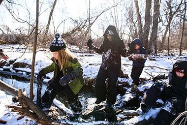
The Kroening Center offers nature programs year-round.
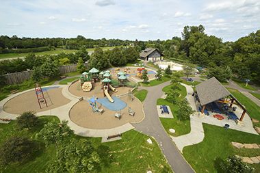
Enjoy a leisurely day in the park as the kids enjoy themselves on the playground.
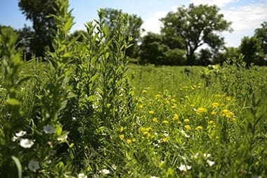
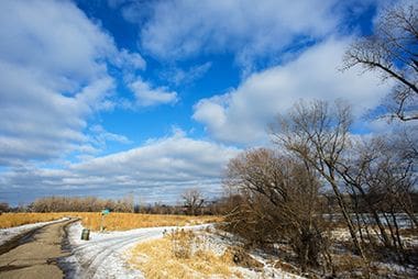
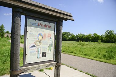
A large portion of the park is maintained as prairie vegetation.
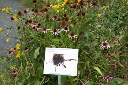
20+ whimsical plant signs line the path between the Nature Center and the playground/wading pool.

Kroening Interpretive Center offers nature programs.
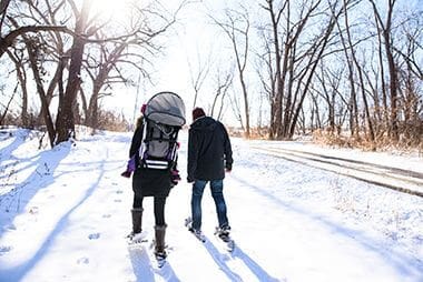
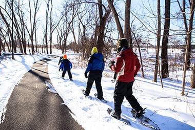
Trails aren't as busy in the winter months, but are maintained as needed so that they remain accessible to pedestrians and bikers.

The Kroening Center offers nature programs year-round.
Cool off in the summer at the popular Wading Pool. See our other wading pool locations.
The Kroening Center offers nature programs year-round.
The Kroening Center offers nature programs year-round.

The Kroening Center offers nature programs year-round.
A trail system through the park connects to Shingle Creek and commuter routes downtown.
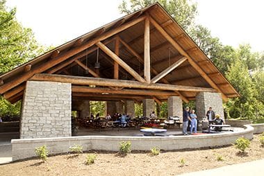
The park has three reservable picnic shelters north of the wading pool.
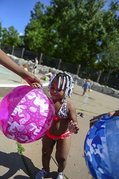
Cool off in the summer at the popular Wading Pool. See our other wading pool locations.
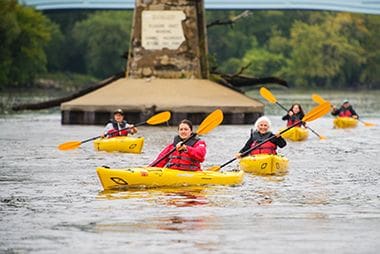
Paddle Share kayak rental is available Fri.-Sun. until the end of Oct. Rent a kayak and learn more at paddleshare.org
There are no announcements at this time. Please check back soon.