


Lake of the Isles Park
Address
2500 Lake of the Isles Parkway E
Minneapolis, MN 55405
Plan Your Route
Contact
Phone: 612-230-6400 Email: info@minneapolisparks.org
Park Hours
6 am-midnight in developed areas
6 am-10 pm in undeveloped areas
Ordinance PB-2-33
Ice Rink Information
Go to the ice rinks page for details on daily hours, dates for the current season, daily status and temporary closures, a full list of locations and more.Lake of the Isles Park
Part of: Minneapolis Chain of Lakes Regional Park
Find a Recreation Center
Features & Amenities
- Biking Path
- Decorative Fountain
- Drinking Fountain
- Fishing Pier
- Hockey Rink
- Ice Skating Rink
- Soccer Field
- Walking Path
- Well
Good to Know
Fishing Pier and Shore Fishing locations:
- Between Newton and Oliver avenues
- Lagoon area connecting Bde Maka Ska and Lake of the Isles
Canoe racks located on the south and northwest sides of lake.
Ice rink and warming room information
Peavey Fountain is located at West Lake of the Isles Parkway & Kenwood Parkway.
Well is located at Lake of the Isles Parkway East & West 28th Street
Park Projects
This park will be affected by park design and improvement projects. View the MPRB Plan for Cedar Lake and Lake of the Isles.

Park Details
Size: 208.36 acres
Trail: Pedestrian (2.63 miles), Bike (2.76 miles)
Neighborhood: Cedar-Isles-Dean, East Isles, Kenwood, and Lowry Hill
Service Area: Southwest
Peavey Fountain was originally given to the people of Minneapolis in 1891 by F. H. Peavey as a drinking fountain for horses. This monument was rededicated as a memorial to the horses of the 151st Field Artillery Minnesota National Guard killed in action in the First World War.
Lake of the Isles is an engineered lake, created in the early part of the 20th Century. The Park Board dredged what was originally a shallow lake and marsh complex and used the dredged material to create parkland and ultimately, a stately and picturesque park.
In 2001, the Park Board began construction of a major project to improve Isles’ water quality, eroding shorelines and damaged recreation areas. The construction project will lessen the impact of the regional watershed that drains into the 120-acre Lake of the Isles and will reconstruct parkland damaged by the disastrous 1997 flood and the devastating 1998 windstorm.
In developing the Lake of the Isles Park renovation plan, the challenge has been to create a sustainable as well as usable park space. Shoreline stabilization, wetland enhancement and restoration, path reconstruction, upland plant restoration, and the raising of passive recreation areas are strategies that have been and are being implemented to achieve the renovation goals, namely to balance aesthetics and the park’s historical integrity with the recreational needs of park users and the sustainability of a fragile environment.
Lake Info
Lake of the Isles is monitored as part of the Minneapolis Park & Recreation Board’s (MPRB) lake water quality monitoring program.
Click here for MPRB lake monitoring info
The Minnesota Department of Natural Resources has details regarding the size, shore length, depth, and other features of the lake.
Rentals & Permits
Athletic Rentals: Call the recreation center directly to reserve a field, court, or rink for a single practice or game. Visit Recreation Center Rentals for details.
Canoe/Kayak Storage Rack Permit: An annual permit allows you to store your canoe or kayak. View canoe/kayak permit details.
Outdoor Use and Event Space: Learn how to reserve park space for corporate events, community celebrations, and more.
Parkway Use: You must obtain a permit for special use of the parkway including closures, and dumpsters, trucks, limousines or carriages on the parkway. View parkway permit details.
Dog Park: Visit the Off-Leash Recreation Area. Permit required.
History
Name: The name of the lake, referring to the islands in the lake, was used from the earliest days of the settlement of Minneapolis. At one time the lake contained four islands. Two islands near the south shore of the lake were converted to land as the lake was developed.
Acquisition and Development
Lake of the Isles did not figure in plans for Minneapolis parks when the park board was created by the state legislature and approved by Minneapolis voters in 1883. The lake, surrounded by wetlands, was not mentioned in any of the discussions leading up to those events. Bde Maka Ska and Lake Harriet, with much better-defined shorelines, and the Mississippi River gorge were considered to be the future gems of the park system.
When landscape architect Horace Cleveland delivered his famous “Suggestions for a System of Parks and Parkways for the City of Minneapolis” to the park board on June 2, 1883, which became the philosophical blueprint for Minneapolis park development, he proposed no developments at Lake of the Isles.
The first mention of Lake of the Isles in park board documents in any context was in October 1884 when Joseph Dean and others offered to donate to the park board a right of way from Hennepin Avenue to Bde Maka Ska, part of the northwest shore of Bde Maka Ska and land for a parkway, now Dean Parkway, from Bde Maka Ska to Lake of the Isles.
The campaign to add Lake of the Isles to the park system was led by Charles Loring, the first president of the park board. Loring, for whom Loring Park is named, was referred to as early as 1886 as the “Father of the Parks.” Loring had been the pivotal figure in securing the shores of Lake Harriet at almost no cost to the park board and he led the effort to replicate that success at Lake of the Isles. He was motivated in part by his desire to create a parkway from Central (Loring) Park out to Lake Harriet by a route other than Hennepin Avenue, which had at that time been designated as a parkway.
In January 1885 Loring wrote in his diary that he would not take his annual winter trip to warmer climes because he was needed in Minneapolis to secure Lake Harriet and Lake of the Isles for the park system. Loring’s vision for a Lake of the Isles boulevard was that it would begin at Hennepin Avenue and Summit Avenue, and follow Summit until it cut southwest to Franklin Avenue, then continue along both sides of the lake to the south.
Even before the park board had designated the shores of the lake for acquisition as a park, Loring wrote in the 1885 annual report that property owners had already agreed to contribute the greater part of the land for the boulevard and that if the rest of the land could be acquired by donation “the Board will feel justified in undertaking its improvement.” Loring had a vision for the land that many others did not. He wrote that improvements could include a “considerable tract of the marsh land on the north side of the Lake, which in time by dredging from the shallow parts of the lake and filling from surplus earth on the banks, may be converted in park areas.” Loring’s experience in supervising the dredging of the pond in Loring Park may have contributed to that vision.
With donations of most of the land arranged personally by Loring, on November 6, 1886 the park board officially designated the lands around Lake of the Isles as a park. With the exception of two tracts of land, the entire shore of the lake was donated, creating a parkway 3.6 miles long.
The finishing touch came in 1887 when the park board purchased the two islands in the lake for $35,000. The board took that action when it learned that the owner of the islands was contemplating building a bridge to the islands and selling lots on them. By that time the park board had already begun work on a parkway along the north end of the lake, which was marsh, and had begun grading the east shore of the lake for a parkway.
The first attempts to improve the shores of the lake came in 1889 when dredging began on the northern arm of the lake. Dredging continued there and on the east shore of the lake until 1893. The improvements to Lake of the Isles were not without controversy. While the dredging was underway in 1892, some commissioners proposed to reduce park board expenditures at Lake of the Isles in favor of improvements to other parks. Those proposals were very narrowly defeated.
Even as the work at Isles generated some opposition, ideas for a grander chain-of-lakes park were being proposed. In the park board’s 1893 annual report, Loring suggested that all of Bde Maka Ska should be acquired by the park board and the outlet from Lake of the Isles to Bde Maka Ska “should be enlarged to permit the passage of boats.” At that time the park board had very limited resources owing to a national economic depression and the idea was not pursued for many years.
In 1905, however, the park board received petitions requesting a channel connecting the lakes. Late in 1905, the park board took a step that would dramatically alter the landscape around Lake of the Isles. The park board hired a new superintendent to replace the retiring William Berry who had been superintendent since 1885. The new superintendent, Theodore Wirth, would promote the radical reshaping of Lake of the Isles. Only two months into his hiring Wirth made several proposals on which he requested immediate action by the park board. One of them seemed innocuous at the time, but was the first step in reshaping Lake of the Isles and Bde Maka Ska, and created the foundation for turning two more swampy lakes, Lake Nokomis and Lake Hiawatha, into new lakes and parks. Wirth’s suggestion in March 1906 was that he be authorized to remove some dangerous curves from the parkway on the west side of the lake. Once he began work on that parkway, he didn’t stop until he had transformed 100 acres of water, 67 acres of swamp and 33 acres of dry land into 120 acres of water and 80 acres of dry land. Wirth also dredged the lake to an average depth of eight feet and significantly expanded the size of the southern island.
As Wirth began supervising the dredging of Lake of the Isles in 1907, a project that he admitted was much more difficult than he expected, the park board acquired more of the land between Lake of the Isles and Bde Maka Ska as well as Kenwood Park north of the lake. In his 1907 annual report Wirth reported on the success of the dredging efforts, mostly on the west and south shores of the lake, noting in particular that the efforts were raising real estate values near the lake. He urged that the dredging of the lake should be the park board’s priority until the project was completed. In 1907 the park board also approved initial plans and estimates for the channel connecting Lake of the Isles with Bde Maka Ska.
Plans were also in the works for a channel between Lake of the Isles and Cedar Lake. In 1909 Anna Lewis donated the land between Cedar and Isles specifically for that connection. Problems with the bridge built to cross that proposed channel however delayed plans for the connection of those two lakes. Unable to complete the connection to meet a condition of Lewis’s donation, the park board paid her $1,000 for the land.
In 1911 the first of the lake connections—to Bde Maka Ska—was completed and led to a week-long civic celebration. In five years the park board had spent $152,000 on dredging, filling and constructing parkways across the new fill at Lake of the Isles. That total did not include the costs of dredging the channel to Bde Maka Ska and building the necessary bridges over the channel.
Once the problems with the bridge over the proposed Kenilworth Lagoon connecting to Cedar Lake were resolved, the dredges returned to Lake of the Isles to make the connection to Cedar Lake. That channel was completed in 1913. The opening of that channel caused the water level in Cedar Lake to drop five feet.
With the completion of the channel, work at Lake of the Isles was substantially done. The board’s 1914 annual report boasted that what had once been a “miasmatic swamp” had become an attractive residential district. The total cost of the transformation had been about $400,000.
It was only a few years, however, before Wirth and the park board determined that significant new investments were needed at Lake of the Isles, especially to repair the parkways. The problem at Lake of the Isles, then and now, is that ground created by dredge fill is often unstable, subject to settling and erosion. Wirth wrote in 1916, that Lake of the Isles had been “sadly neglected” and suffered from “unsightly appearance.”
Improvements to the parkway didn’t get underway until 1923 when work began to pave and curb the parkway for the first time.
The problem of settling fill around the lake remained however. In 1928 Wirth recommended lowering the water level in all lakes by six inches because of shoreline problems at Lake of the Isles. That was finally done in 1935, despite problems of low water in the lakes in intervening years. To even maintain the lakes at the lowered level, however, the park board pumped city water into the lakes to keep them from being too low in the late 1930s. Writing of the problem years later, park superintendent Charles Doell speculated that the lake levels Wirth considered “normal” at the time of the dredging, were probably actually above historical norms. In 1950 the park board dredged the channel between Isles and Bde Maka Ska to make it deeper to keep it open to boats, but by the late 1950s not even canoes could pass through the channel.
During those low-water years many city lakes saw a great growth in aquatic plants, leading in 1959 to sodium arsenite treatments of the lakes, including Lake of the Isles. The problem of aquatic plants re-emerged in 1987 when the first Eurasian milfoil was identified in Lake of the Isles. By 1996 the invasive plant had spread to all other lakes in the chain of lakes, which has led to harvesting of the plant in several lakes under license from the Minnesota Department of Natural Resources.
In the late 1960s another concern emerged about the city’s lakes: water quality. One of the unanticipated results of eliminating wetlands around the lakes, and the full development of surrounding property, was a decrease in lake water quality. There were no wetlands to serve as natural filters for storm water runoff from surrounding land. Of course in Wirth’s time the goal was to make sections of the city more appealing to attract development. Decades later, people realized one of the problems, for water quality at least, was too much development.
The combination of a concern for water quality along with unusually wet weather in the 1990s that flooded parts of the shore of Lake of the Isles prompted the park board to develop a master plan to stabilize the shore line, restore some wetlands and fill others created by high water. The master plan was completed in 1998 and some components of the plan were not completed until 2008. The total cost of completing the master plan exceeded $10 million. Much of the funding for the improvements came from the state legislature through the Metropolitan Council.
Following the extensive work to stabilize the shoreline, in 2008 the park board also performed extensive restoration on the wildlife refuges on Mike’s and Raspberry Islands. Arbor Day was celebrated at Lake of the Isles in 2008 and 125 trees were planted near the north shore of the lake. Lake of the Isles Parkway was resurfaced in 2009.
In 2014 engineers were hired to take a closer look at alternatives to the proposed bridge needed to cross the channel. After careful examination of the report issued by the engineers and consulting with its legal team, the park board determined an alternative option – tunneling under the channel – was feasible but it added construction time and cost to the project that rendered it not prudent.
In February 2015 the park board reached an understanding with the Metropolitan Council, the public agency overseeing the project, and in September the design of new bridges over the channel was approved.
Trivia
In 1910 the park board accepted the offer of John Bradstreet, a park commissioner 1901-1907 and influential interior designer, to build a Japanese temple on one of the islands in Lake of the Isles. Bradstreet’s work for many of Minneapolis’s elite families had been strongly influenced by Japanese design. Plans for the project never materialized.
The first park board ordinance to prevent canoe landings on the islands in Lake of the Isles was passed in 1919.
During the Great Depression when nearly all maintenance work in the city’s parks was done under federal work relief programs, a masonry shoreline retaining wall was built at Evergreen Point on the lake by the Works Progress Administration. The WPA also built shoreline retaining walls on sections of Bde Maka Ska, Lake Harriet and Lake Nokomis. The wall at Lake of the Isles was replaced in 2003.
Park history compiled and written by David C. Smith.
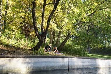
Picnic in the Park
Channels are also just a pleasant place to sit and watch nature go by.

Ice Skating
Skate on the lake or in the ice rink, and step into the warming house if you need a break from the cold.

Winter Trails
Our paved trails are consistently maintained throughout the winter months for year-round enjoyment.
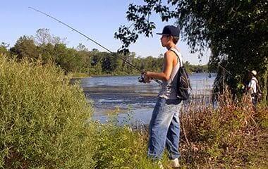
Fishing
Lake of the Isles has a fishing pier and offers easy access to the water for shore fishing.
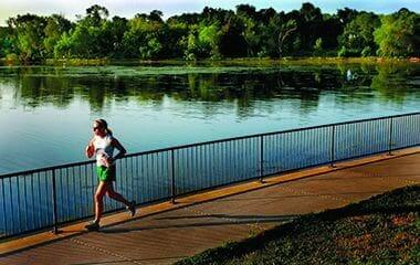
Trails
Lake of the Isles has 2.63 miles of pedestrian trails and 2.76 miles of bike trails encircling the lake.
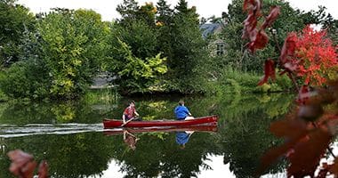
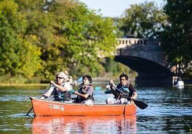
Canoeing
Keep your watercrafts at one of two storage racks located on the Northwest and South sides of the lake.
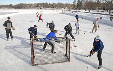
Ice Hockey
The hockey rink is located at East Lake of the Isles Parkway and West 26th Street.
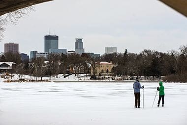
Cross Country Skiing
The Chain of Lakes Trails are great for beginners or anyone wanting a leisurely ski through some of Minneapolis' most beautiful areas.

Wildlife
Shoreline stabilization, wetland enhancement and restoration, path reconstruction, and upland plant restoration are strategies being implemented to balance aesthetics with the sustainability of a fragile environment.
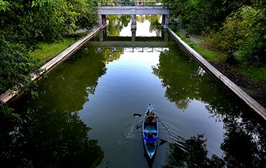
Water Channels
Canoe through the channels that connect the Chain of Lakes.
Winter Lake
The Chain of Lakes Trails are great for beginners or anyone wanting a leisurely ski through some of Minneapolis' most beautiful areas.
Canoeing
Keep your watercrafts at one of two storage racks located on the Northwest and South sides of the lake.
Park Board Announcements
There are no announcements at this time. Please check back soon.