


East Bank Trail – Graco
James I Rice Parkway
Minneapolis Park and Recreation Board Headquarters
Upper Harbor Terminal
Upper River West Park
West River Parkway
East and West banks of the Mississippi River between Plymouth Avenue North & Camden Bridges
General: 612-230-6400
Email: info@minneapolisparks.org
6 am-midnight in developed areas
6 am-10 pm in undeveloped areas
Ordinance PB-2-33
East Bank Trail – Graco
James I Rice Parkway
Minneapolis Park and Recreation Board Headquarters
Upper Harbor Terminal
Upper River West Park
West River Parkway
This park will be affected by several park improvement projects.
Not finding what you’re looking for?
Search Parks & Destinations
Paths connect to:
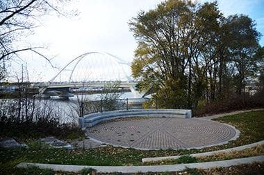
Public Art: The Sheridan Veterans Memorial, honoring all Minnesota veterans, is centered around a large spherical sculpture of protective shields, created by local artist Robert Smart.
Size: 15.39 acres
Neighborhood: Bottineau, Hawthorne, Marshall Terrace, Sheridan
Service Area: North, Northeast
Commissioner District: 1, 2
Outdoor Use and Event Space: Learn how to reserve park space for corporate events, community celebrations, and more.
Outdoor Weddings: Make your outdoor ceremony unique and memorable. View wedding permit details.
Parkway Use: You must obtain a permit for special use of the parkway including closures, and dumpsters, trucks, limousines or carriages on the parkway. View parkway permit details.
Food Truck Permit: City of Minneapolis licensed food truck operators can apply for a one-day permit at this
park. View food truck permit details.
The area known as “Above the Falls” lies upriver of St. AnthonyFalls alongside both the east and west banks of the Mississippi River and extends to city limits. The history of the Above the Falls area differs significantly from the histories of most other parks in the Minneapolis park system. While small portions of this area are parkland, the vast majority of it has been developed for other uses.
Because of its proximity to the river and particularly to St. Anthony Falls, land now considered Above the Falls has long been a precious resource to inhabitants. Native American people from the Anishinabe and Dakota tribes lived on the lands surrounding the river prior to the influx of European settlers. The river provided water, food, medicinal plants, recreation and natural beauty. In addition, the Dakota peoples ascribed spiritual importance to the Falls.
As European settlers began arriving to the area, the Falls became the center of industrial activity. The river provided not only access to transportation up and down the Mississippi, the Falls supplied hydropower to run grain, grist and lumber mills. With the construction of rail lines in the late 19th century and the subsequent increase in market, lumber and flour mills were able to generate their products at much higher rates. By the late 1800s, lumber mills relied on steam power rather than hydropower and could therefore easily be located north of the Falls. The area upriver of St. Anthony Falls was primarily dominated by lumber mills.
In the early 1900s, the river was also a source of recreation and hygiene for the general population. Public baths operated along the banks of the Mississippi, north of the industrial center but still in adjacent to several areas of production. In a time before indoor plumbing was available and affordable to many people, public baths provided access to sanitation and recreation. By 1930, the public baths were closed.
With depleted forests came the decline of the lumber business in the early 20th century. Lumber mills closed down as a result and by 1919, there were none left in Minneapolis. Instead, the area upriver from the Falls became populated by salvage yards. Steel mills located themselves in proximity to take advantage of these reuse/recycle centers, maintaining the industrial environment and development of the area. These industries are still a visible presence in the area.
Native Americans and the Mississippi River
For thousands of years, numerous Native American cultures have used and inhabited lands along the Mississippi River. In Minnesota, Native American occupancy of lands along the river began as early as 12,000 years ago. These lands would have been ideal for either short-term camps or long-term habitation, for the river provided food, drinking water, water for cooking and for bathing, medicinal plants, recreation, and places of beauty. Both the Dakota and the Anishinabe, who were living on lands surrounding the Mississippi River when Europeans first arrived in Minnesota, realized the benefits of the river. At the time of European contact, the Dakota were the primary occupants of the St. Anthony Falls area. They found St. Anthony Falls to be a place of not only practical importance, but also of spiritual importance, as the water under the falls was occupied by the spirit of waters and evil, Oanktehi.
Steam-Powered Lumbering Above the Falls
When the first Europeans settled in the area of St. Anthony Falls, they, too, were quick to recognize the benefits of the Mississippi River, albeit benefits of a different nature. They knew that the Falls could be used to power lumber mills and gristmills, and that the river could be used to transport raw materials to the mills. With the widespread adoption of steam power in the late-1800s, however, the lumber mills no longer relied on the Falls for power, and the area north of the Falls became the lumber-milling center of Minneapolis. The Plymouth Mill was located along the river at Plymouth Avenue North, and the Diamond Mill was located along the river at 18th Avenue North. Numerous lumberyards lined the river to the east of First Street North, and related industries located operations in proximity to the lumber mills, including the Bardwell, Robinson & Company sash, door, and blind factory at 24th Avenue North and First Street North, as well as the Minneapolis Cedar Post Company and the Carver, Young, & Clark sash, door, and blind factory, both just south of the Diamond Mill. The Anderson & Johnson planning mill and the Joannin, Hansen, & Company sash, door, and blind factory were located at the northwest corner of First Street North and 14th Avenue North. In the late 19th and early 20th centuries, the lumber mills above the Falls, along with the flour mills to the south, constituted the economic foundation of Minneapolis. From 1899 to 1905, the mills above the Falls made Minneapolis the top sawmilling center in the nation. The economic success of these mills continued until timber stands were depleted in the early twentieth century. By 1919, no lumber mills were left in the city.
Railroads Along the Mississippi River
Another advantage came to the river-based industries located above the Falls when the railroads made their way to the area. The St. Paul & Northern Pacific Railway Company constructed a line from Sauk Rapids to Minneapolis in 1884, a portion of which ran along the east side of First Street North from Plymouth Avenue North to 23rd Avenue North before veering east to and over the river. An associated roundhouse was constructed on the southwest corner of Plymouth Avenue North and First Street North. Within two decades, the First Street portion of the St. Paul & Northern Pacific Railway (sold to the Northern Pacific Railway Company in 1896) would be joined by the Minneapolis, St. Paul & Sault Ste. Marie line, and the tracks of both lines would consume nearly all of the land between First Street North and the Mississippi River from Plymouth to 20th avenues. Though the Northern Pacific roundhouse was demolished after WWII, a roundhouse was built at 24th Avenue North near the river for the Chicago, St. Paul, Minneapolis, & Omaha Railway during that period. The early railroad lines of northern Minneapolis were part of a network that connected Minneapolis to the rest of the country and allowed it to become a national economic force.
Building Bridges to Northeast Minneapolis
During Minneapolis’ period of great growth throughout the mid-to-late 1800s, the river was a tremendous asset, but it also constituted a natural barrier between northeast Minneapolis and the rest of the city. To expedite travel across the river in the area above the Falls, several bridges were constructed. These included the Plymouth Avenue Bridge, or Upper Bridge, constructed in 1873 to join St. Anthony to Minneapolis a year after those cities consolidated; the St. Paul & Northern Pacific Railway bridge, constructed as part of the railroad in 1884; and the Broadway Avenue Bridge, constructed in 1887.
The Plymouth Avenue Bridge was originally constructed as a wooden truss structure but was replaced by an iron truss bridge in 1886. Nearly 100 years later, it was reconstructed as the current concrete span bridge.
The Broadway Avenue Bridge was constructed as an iron truss bridge and was considered to be among the most decorative of Minneapolis bridges over the Mississippi River. When the Broadway Avenue Bridge was reconstructed as a concrete span bridge in 1987, a portion of the original bridge was relocated to span the river from Nicollet Island to Main Street, and it can still be viewed there today, as the Merriam Street bridge.
The Gerber Baths on Hall’s Island
In contrast to the industries above the Falls were the Gerber public baths located on the east bank of the river. While the railroad made some industries less reliant on the Mississippi River for transportation, people began to once again realize the health and recreational benefits of the river. During the early 1900s, the Gerber Baths were located at Hall’s Island, north of the Plymouth Avenue Bridge. In early twentieth-century Minnesota, municipal baths located on the Mississippi River and at various lakes were a popular form of recreation, but they were established primarily to promote the good health of poor and working-class people in the days before indoor plumbing was available or affordable to the general public. Buildings on the grounds of the Gerber Baths included two dressing rooms and a refectory, or dining hall, along with a playground. On Sundays, band concerts were performed and silent movies were shown outdoors on Hall’s Island. In the 1920s, public baths along the Mississippi River were closed down as it became increasingly polluted. For this reason, the Gerber Baths fell out of use in 1924 and were permanently abandoned by the City of Minneapolis in 1926. In 1929, days before the wrecking crew was scheduled to demolish the Gerber bathhouse, a stray Fourth of July skyrocket lodged in its roof, causing it to burn to the ground.
Reuse and Recycling Above the Falls
Perhaps fittingly, after lumber supplies were depleted and the lumber mills departed, the area above the Falls became a sire of recycling and reuse. By the early 1920s, this area had been converted to storage and salvage yards, primarily for automobiles. These yards served and continue to serve the important function of collecting discarded automobiles and other large debris produced by a large urban population. Usable parts from some appliances and machinery are removed and sold for reuse, and scrap metal is sold to steel plants and recycled. Many steel plants benefited by locating near the salvage yards, thereby maintaining the industrial character of the area. Among the earlier steel mills in the area were the Scott-Atwater Foundry Company, west of First Street North between 22nd and 23rd avenues, and the Diamond Iron Works, still visible today at 1728 Second Street N.
Park history taken from the Above the Falls – Phase I Report.
The City of Minneapolis and the Minneapolis Park and Recreation Board jointly approved a far-reaching vision for the City’s upper Mississippi riverfront, entitled Above the Falls: A Master Plan for the Upper River in Minneapolis. The plan called for continuous park frontage along both sides of the river, new residential neighborhoods, and job growth along with a reduced industrial footprint.
Since the plan’s adoption, significant implementation steps have been achieved, including park and trail expansion, renovation of the Grain Belt complex, and establishment of the Minneapolis Riverfront Partnership. The plan also established the Above the Falls Regional Park (ATF) that extends along the riverfront from Plymouth Avenue north to the Camden Bridge. This regional park is recognized by the Metropolitan Council, allowing the Park Board access to vital state and regional funding sources. Consistent with MN Statute 473.313 the Metropolitan Council requires a master plan to be developed and updated regularly for each regional park, park reserve, trail and special recreation feature.
In 2012, the Park Board and the City of Minneapolis jointly engaged in an effort to update the plan entitled Above the Falls: A Master Plan for the Upper River in Minneapolis. The plan update was adopted by the park board in 2013. It included recommendations for land-use policy, park development, phasing, implementation strategies and environmental stewardship within the Above the Falls plan area.
Since 2010, city staff have been working on the ATF Policy Review and Implementation Study (PRIS) to explore policy and regulatory strategies for providing existing property owners clearer expectations about the phasing of long-range land use transitions and to analyze potential impacts of the ATF land use guidance related to the extent and phasing of the transition from industrial to nonindustrial development.
More History
Edgewater Park
Gluek Park
Marshall Terrace Park
Minneapolis Park and Recreation Board Headquarters
Orvin “Ole” Olson Park
Sheridan Memorial Park
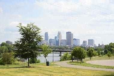
Take in the beauty of the Mississippi River from the several outlooks throughout Above the Falls Regional Park, including in Edgewater Park.
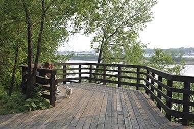
Take in the beauty of the Mississippi River from the several outlooks throughout Above the Falls Regional Park, including Marshall Terrace Park.

The Sheridan Veterans Memorial, honoring all Minnesota veterans, is centered around a large spherical sculpture of protective shields, created by Robert Smart.
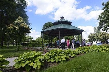
The shelter at Gluek Park is a popular wedding& spot.
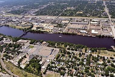
The park encompasses the East and West banks of the Mississippi River between the Plymouth Avenue & Camden Bridges.
The walking and bike paths through Orvin "Ole" Olson Park connect to James I Rice Parkway and West River Parkway.
There are no announcements at this time. Please check back soon.