


26th Avenue North Overlook
Address
East terminal of 26th Avenue N at the Mississippi River
Plan Your Route
Contact
General: 612-230-6400
Email: info@minneapolisparks.org
26th Ave N Overlook
Part of: Above the Falls Regional Park
Park Projects
This park will be affected by the 26th Avenue North Overlook project and the 26th Avenue North Overlook and Ole Olson Park Trail Connection project.
Features & Amenities
- Riverfront Beacon
- Overlook Platform
- Play Netting
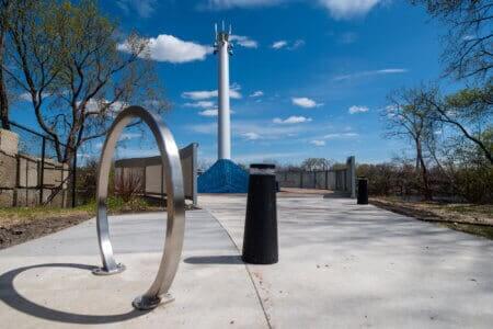
- Bike Racks
- Benches
![]()
This project is part of RiverFirst, a generational vision for transforming 11 miles of once-industrial Mississippi Riverfront into a welcoming place for all people through improved habitat and miles of new interconnected parks and trails.
Park Details
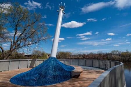
The oval-shaped Overlook platform centers around a 35-foot-tall riverfront beacon that leans toward the water. The beacon light can display a variety of colors but stays dark during spring and fall migratory periods to protect birds in the Mississippi Flyway.
Rentals & Permits
Outdoor Use and Event Space: Learn how to reserve park space for corporate events, community celebrations, and more.
History
Name: The 26th Avenue North Overlook is named for its location, where 26th Avenue North meets the Mississippi River. The Overlook marks the first phase of a broader project known as the Great Northern Greenway River Link. The broader vision for the River Link includes connections to downtown Minneapolis and West River Road walking and biking trails, together with new parks stretching north and south from the Overlook along the riverfront. Once complete, the full River Link will unite downtown to North Minneapolis along the river, open up a new 40-mile trail loop in Minneapolis, and eventually reach to Northeast across the river to nearly complete Great Northern Greenway trails in Northeast Minneapolis.
Acquisition and Development: The 26th Avenue North Overlook is part of RiverFirst, an initiative adopted by the Park Board in 2012 to develop riverfront parks and trails on both sides of the Mississippi River from the northern city limits to Downtown.
The construction of I-94 in the 1950s created a barrier between North Minneapolis and the Mississippi River. The highway and industrialized riverfront limits access to one of the city’s most beloved natural amenities. In 2017 the City of Minneapolis finished rebuilding 26th Avenue North, which included a new off-street bike/walk trail spanning North Minneapolis. This trail travels past Farview Park and Nellie Stone Johnson Community School, connecting the river to Theodore Wirth Regional Park across the heart of North Minneapolis.
The Overlook was completed in May 2021. Its location at the eastern end of 26th Ave N makes it a natural pivot point bringing parks users and bike commuters from North and Northeast Minneapolis across the city and into Downtown. By locating the new park at this juncture, the overlook will eventually extend the existing Ole Olson Park north and creates a staged reconnection of Farview Park to the river.
Other RiverFirst projects include Hall’s Island, a habitat-rich island and gravel beach restored in 2018 after it was destroyed by 1960s industrial expansion, and Water Works, a new park space and pavilion that also opened in the summer of 2021, located in Mill Ruins Park next to the Stone Arch Bridge.
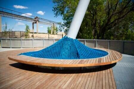
26th Ave N Overlook Sculpture Base Closeup
Photos of the grand opening press conference for the 26th Ave Overlook in North Minneapolis.
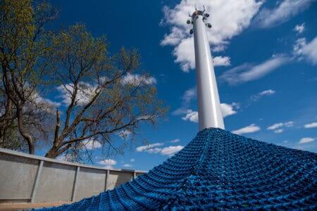
Closeup of Sculpture Looking Upward 26th Ave N Overlook
The new 26th Ave N Overlook project nears completion. April 2021
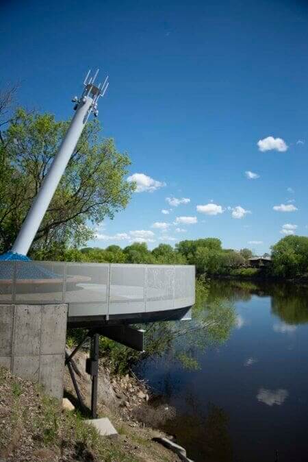
26th Ave N Overlook Sculpture River View
Photos of the grand opening press conference for the 26th Ave Overlook in North Minneapolis.
26th Ave N Overlook Sculptures
The new 26th Ave N Overlook project nears completion. April 2021
26th Ave N Overlook Sculpture Sideview Closeup
The new 26th Ave N Overlook project nears completion. April 2021

26th Ave N Overlook Sculpture Sideview
The new 26th Ave N Overlook project nears completion. April 2021
Park Board Announcements
There are no announcements at this time. Please check back soon.