


Victory Park
Park Hours
6 am-midnight
Ordinance PB-2-33
Wading Pool Information
Features & Amenities
- Basketball Court
- Drinking Fountain
- Picnic Tables
- Playground
- Restroom Facility
- Soccer Field
- Tennis Court
- Splash Pad
Not finding what you’re looking for?
Search Parks & Destinations
Park Projects
Victory Park Improvements Project (2019 – 2025)
![]()
Your NPP20 money at work:
Maintenance is increasing at all neighborhood parks, thanks to additional annual funding from the 20-Year Neighborhood Park Plan (NPP20). This initiative also funds ongoing rehabilitation and major project to restore neighborhood parks and help address racial and economic equity.
Park Details
An annual Memorial Day concert, sponsored by the Victory Neighborhood Association and Webber Community Center, is held at the Victory Memorial Drive flag pole the Thursday before Memorial Day.
Rentals & Permits
Outdoor Use and Event Space: Learn how to reserve park space for corporate events, community celebrations, and more.
History
Name: The park was named for the Victory neighborhood in which it is located. The neighborhood took its name from Victory Memorial Drive, the name given to the parkway from Columbia (Wirth) Park to Camden (Webber) Park when it was dedicated in 1921. Victory Memorial Drive was named in the aftermath of World War I after Charles Loring, the first president of the park board and known as the “Father of Minneapolis Parks,” donated the money to plant and care for a row of elm trees along each side of the parkway. Each elm was dedicated to a fallen American soldier from Hennepin County. Appropriately, Victory Park is adjacent to an elementary school named for Loring. The first Charles Loring School was built on the site in 1924, but was replaced by a brick building in 1928.
Development and Acquisition
Victory Park is one of the only Minneapolis parks that was developed before it was acquired. The first reference to the park in park board proceedings was in April 1974 when the park board noted that it had approved a verbal report from representatives of the Victory neighborhood, presumably concerning development of a playground next to the school. By 1976 the park board had approved a design program for the park and a year later approved schematic plans for a park, including a recreation shelter, at a cost of $177,000. The board also authorized a payment to the school board of roughly $46,000. Exactly what that payment covered is not clear. In addition to playground equipment, the park was provided with a wading pool and a basketball court.
Despite the construction of the park and shelter adjacent to Loring Elementary School, the park board and school board did not sign a lease agreement for the property until 1980.
The park was significantly upgraded in 1998 with the cost divided between city bonds and Neighborhood Revitalization Program funds designated by the neighborhood. At that time the neighborhood requested the removal of the basketball court in the park, as it was viewed as incompatible with the park’s design primarily to appeal to young children.
In 2019, construction by the Minneapolis Public Schools district at Loring Elementary School affected the wading pool’s mechanical room, requiring the closure of the pool. In response, MPRB moved up the timeline for a planned improvements project (funded by the 20-Year Neighborhood Park Plan), which replaced the pool with a splash pad and other improvements based on the recently approved long-term vision plan for the park. Following delays stemming from the COVID-19 pandemic and other factors, the project was completed in spring 2025 and the splash pad became the fourth such feature in the park system.
Victory Memorial Drive
Name: The parkway was originally named Glenwood-Camden Parkway when the land was acquired for the parkway in 1911, referring to its route from Glenwood Park to Camden Park. (Before the name was adopted it was referred to informally as North Side Parkway.) It was officially named Victory Memorial Drive in 1919 and included all of Memorial Parkway, and what is now Theodore Wirth Parkway and Cedar Lake Parkway. Although still commonly referred to as Victory Memorial Parkway, the name was changed to Memorial Parkway in 1968 and applies only to the parkway from Lowry Avenue to Webber (Camden) Park.
Acquisition and Development
The idea of a parkway encircling the city, today’s Grand Rounds, is nearly as old as the park board itself. When landscape architect Horace Cleveland submitted to the first park board his formal “suggestions” for a system of parks and parkways in 1883 he envisioned parkways connecting major parks in each section of the city. His original vision for a system of parkways was largely achieved decades later, although most of those parkways ended up being further from the center of city than Cleveland would have liked.
The first suggestions for a parkway in northwest Minneapolis came in 1884 when commissioners proposed a parkway around the western shore of Cedar Lake and from there through north Minneapolis to Farview Park. Some commissioners thought this was a more scenic and certainly less expensive route for a parkway into north Minneapolis than a direct route form Loring Park to Farview Park along Lyndale Avenue North. The western route had the advantage that the owner of considerable land west of Cedar Lake and in north Minneapolis, William McNair, had offered to donate land for a parkway.
Recognizing that the best route for that parkway would actually pass outside of Minneapolis city limits into what is now Golden Valley, the park board even went so far as to introduce a bill to the state legislature in 1885 that would give the park board the power to acquire land outside the city limits. The legislature granted that power to the park board.
In the summer of 1885, the park board arranged a meeting with McNair, a close friend of several of the first park commissioners, to acquire a strip of land 150-feet wide for the parkway. Charles Loring, the president of the park board then, wrote in 1890 that ultimately the board rejected McNair’s offer of free land because the route around Cedar Lake was too far from the city. McNair died in the fall of 1885 and the matter was not pursued. (Many years later the park board had discussions with McNair’s heirs about acquiring that land once again, but other than the purchase of some of McNair’s land along Cedar Lake, nothing came of the those discussions.)
The idea of a parkway around the city was revived by park commissioner William Folwell in 1891, after the acquisition of the first sixty acres of Saratoga Park, which would eventually be renamed Glenwood Park, then Theodore Wirth Park. In a special report to the board on park expansion, Folwell urged the board not to limit parkway development to the southwestern part of the city around the lakes. Giving the credit for the idea to his friend Horace Cleveland, Folwell proposed a parkway around Cedar Lake, through the new Saratoga Park to a large northwestern park, then across the city to another large park in northeast Minneapolis, continuing down Stinson Boulevard to the Mississippi River at the University of Minnesota, and then along the river to Minnehaha Park. Folwell suggested the parkways could be called the “Grand Rounds.”
The idea—and the name—struck a chord, but before the park board could build the connecting parkways, it needed the anchoring parks. And those would take many years to acquire. Keeping the idea of a northwestern parkway alive, Folwell wrote in 1901 that “but for the sudden deaths of two publicspirited citizens, the Hon. W.W. McNair and the Hon. Eugene M. Wilson, the grand rounds would long since have been extended from Calhoun to Glenwood Park and thence along the west boundary of the city to the north line.”
The idea of the northwestern parkway came up again in 1909, after the board had expanded Glenwood (Wirth) Park from its original sixty-six acres to more than eight hundred acres and also acquired Camden (Webber) Park in north Minneapolis. The park board had acquired Columbia Park in northeast Minneapolis less than two years after Folwell’s proposal. With parks to connect, the desire to build parkways between them took on new urgency.
At the end of 1909, the park board asked park superintendent Theodore Wirth to prepare plans for a parkway from Glenwood Park to Camden Park. The following year, July 21, 1910, the park board designated land for the parkway, on the condition that residents of the area would not request improvements on the land for some years, except for opening a road from 19th Avenue North (Golden Valley Road) into Glenwood (Wirth) Park. With only that stretch of road completed residents of north Minneapolis would have a parkway connection to the lakes in south Minneapolis and Minnehaha Park beyond. The only controversy surrounding the location of the new parkway, which was through open farmland, was whether the east-west section should follow 43rd Avenue or 45th Avenue. The preference expressed by the Camden Park Commercial Club for 45th Avenue seemed to resolve the issue for the board.
A total of 170 acres were acquired for the parkway at a cost of nearly $170,000. The parkway on the western city limit was 333-feet wide and the east-west section on 45th Avenue was 200 feet wide. The cost of the land for the parkway, along with land for the expansion of Glenwood Park and the purchase of the west shore of Cedar Lake, a total of $350,000, was paid for partly (30%) with bonds and the remainder with assessments on property deemed to be benefited by the new parkway.
Construction of the parkway, in keeping with promises that it would take some time, began in 1913 when the parkway was built from 16th Avenue North to 19th. The next stage of the parkway from 19th to Lowry Avenue was begun in 1916, but due to spending constraints during World War I wasn’t completed and opened to traffic until 1920. Park superintendent Theodore Wirth called the parkway “one of the most impressive parts of the Grand Rounds system.” In the 1916 annual report, Wirth
presented plans for completing the parkway north of Lowry Avenue, then east to Camden (Webber) Park. Noting that “the country traversed is rather uninteresting,” Wirth proposed a straight parkway on the west side of the land, leaving space on the east side of the parkway for playgrounds and athletic fields.
Wirth altered his plans for the parkway in 1919 when former park board president Charles Loring made a generous offer to the park board. (Loring had already donated to the park board the recreation shelter in Loring Park and had paid for the construction of an artificial waterfall flowing into Wirth Lake.) Loring had long desired to create a memorial to American soldiers. In 1908 he had commissioned a young Minneapolis architect, William Purcell, to design a memorial arch dedicated to soldiers. Where he hoped to place the arch is not known. But in the wake of World War I, Loring proposed another kind of monument; he would plant memorial trees to soldiers along the city’s parkways. Wirth had a better idea. He thought the planned Camden-Glenwood Parkway was the ideal place to plant rows of stately elm trees as a memorial. Loring liked the idea and agreed to pay for the trees and deposit $50,000 for their perpetual care. The result was a memorial drive, with the parkway centered on the strip of land, instead of off to one side.
The board accepted Loring’s offer, named the new parkway Victory Memorial Drive, and Wirth set out to find the perfect tree. He found a type of elm, called the Moline elm, in nurseries in Chicago and New York, and brought them to the park board’s nursery at Glenwood (Wirth) Park in 1919, so they would be well-established for replanting along the parkway when it was finished.
With memorial trees ready to be planted, and an additional 5.3 acres of land acquired for a monument at the northwest corner of the parkway, the final three miles of the Victory Memorial Drive were completed in 1921. On June 11, 1921 the new parkway, and its news trees, were dedicated in a grand ceremony. Loring, then age 87, was not healthy enough to attend, but drove over the new parkway the day before with his old friend William Folwell.
Later that year both General John Pershing and Marshal Ferdinand Foch, the French commander of Allied forces during World War I, visited the parkway and expressed their admiration for the living memorial. The name of each soldier from Hennepin County who had died in war was placed on a wooden cross in front of a tree. Unfortunately the special elms selected for the drive weren’t hardy enough for Minnesota’s winters and were replaced in 1925.
The wooden crosses were replaced as well in 1928, on the tenth anniversary of the end of World War I, when bronze crosses and stars, each inscribed with the name of a soldier, were installed.
The original wooden flag pole installed as a monument where the northbound parkway turns east at 45th Avenue was replaced by a bronze flag pole and ornamental base in 1923 by the American Legion of Hennepin County. A statue of Abraham Lincoln, a replica of St. Gaudens’ famous sculpture, was installed at the intersection in 1930.
Other than taking out the original bridle paths that were built along the parkway, the parkway remains much as it was when it was constructed. The only other change is that many of the majestic elms in two rows beside the parkway succumbed to Dutch Elm disease in the 1970s and after. Now a less uniform growth of a variety of trees covers the parkway with shade.
In November 1959, the park board received a scare when consultants hired by the Hennepin County Board recommended that the county take over the parkway for the purpose of creating a county highway. The park board registered its opposition to the proposal in early 1960, as did the Veterans of Foreign Wars, who opposed the “desecration” of memorials to soldiers.
While the conversion of Memorial Parkway into a freeway appears not to have been seriously considered, two years later the board still included Victory Memorial Drive among parks and parkways that could be reduced or lost to freeways. During the 1960s and after when freeways were built across the city, the park board did lose two parks (Wilson Park and Elwell Park) and parts of several more to freeways. But all of those losses were for interstate freeways, not county highways.
Park history compiled and written by David C. Smith except for the fifth paragraph, by MPRB staff.
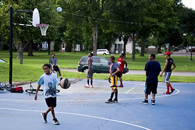
Basketball Court
Sign up for one of our many year-round youth and adults sports leagues.
Victory Park Pee Wee Sports
An annual Memorial Day concert, sponsored by the Victory Neighborhood Association and Webber Community Center, is held at the Victory Memorial Drive flag pole the Thursday before Memorial Day.

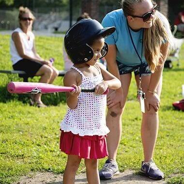
Victory Park Community Events
An annual Memorial Day concert, sponsored by the Victory Neighborhood Association and Webber Community Center, is held at the Victory Memorial Drive flag pole the Thursday before Memorial Day.
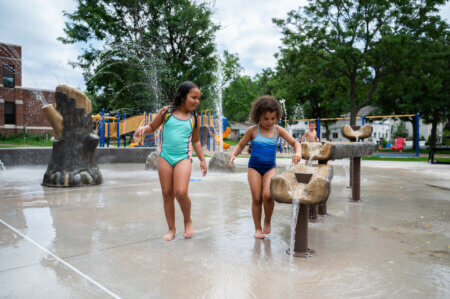
Splash Pad
The new splash pad opened in summer 2025.

Community Events
An annual Memorial Day concert, sponsored by the Victory Neighborhood Association and Webber Community Center, is held at the Victory Memorial Drive flag pole the Thursday before Memorial Day.
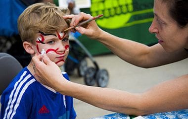
Facepainting
An annual Memorial Day concert, sponsored by the Victory Neighborhood Association and Webber Community Center, is held at the Victory Memorial Drive flag pole the Thursday before Memorial Day.
Park Board Announcements
There are no announcements at this time. Please check back soon.