


Sumner Field Park
Park Hours
6 am-midnight
Ordinance PB-2-33
Features & Amenities
- Drinking Fountain
- Restroom Facility
- Walking Path
Park Projects
This park will be affected by a park improvement project. View Sumner Field Park Basketball Court Improvement.
Park Details
Rentals & Permits
Outdoor Use and Event Space: Learn how to reserve park space for corporate events, community celebrations, and more.
History
Name: The park was named for Sumner Place, a street that once went through the park. The street was named for Charles Sumner, a United States Senator from Massachusetts and ardent opponent of slavery. The park was officially named December 18, 1911. A bit of trivia: Horace Cleveland, the pioneer landscape architect who campaigned for years for Minneapolis to preserve its lake shores and river banks as parks, proposed in 1883 the creation of a system of interconnected parks in the city, and designed the layout of many of the city’s first parks, participated as a young man in a book club organized by his brother in Boston. Another member of the “Five of Clubs” was Charles Sumner, before he was a senator.
Acquisition and Development
The first three acres of the park were purchased, mostly by condemnation, in 1911. In the summer of that year the park board received a petition from the Associated Jewish Charities for a park in what was called the “Jewish district” of the neighborhood. The park board reported that it had difficulty finding a suitable location in the area that was not already built up and could be purchased with “available means.” It reported that a location had been found in the area between 8th and 11th and Dupont and Bryant that was centrally located and “will serve the purpose” if it could be had at a “sufficiently low price.”
Unable to reach purchase agreements with all the property owners, the board assigned appraisers to establish the value of the desired lots for condemnation. After hearing objections to the appraisals, the park board proceeded to purchase the land anyway, including five lots owned by Syracuse University, in December 1911 for $16,000. The original purchase was three acres of land that included the north half of the block between 8th and 9th, the whole block from 9th to 10th and part of the block north of 10th. The land for the park was unusual among neighborhood parks in the city in that it had no street boundaries on the north or south.
Park superintendent Theodore Wirth wrote in his 1911 annual report that the park would need about 4,000 cubic yards of fill to raise it above the grade of the sewer. In his next annual report Wirth included a plan for the park, including an “ordinary” field house, outdoor gymnastic areas, a playground, a football/baseball field that would double as a skating rink, and courts for volleyball, basketball and tennis. His estimate for executing his plan was $15,500.
In 1912, the park board began filling the land and created a skating rink for the winter. It continued filling the land the next year and created a larger rink. Wirth also noted in his 1913 report that the graded field was already being used for baseball.
The park board continued to improve the park gradually, adding tennis courts in 1914 and playground equipment and fencing in 1915. By then Wirth noted that the park was “intensively used,” one of the “busiest fields in system.” He added that toilets were “absolutely necessary” and that the park was not large enough and should be expanded south to 8th Street.
The park board was trying to expand the park a bit at a time. One lot was purchased for $300 for the park in 1914, but the demand for more land persisted. The Federation of North Side Improvement clubs urged expansion and improvement of the park in 1915, and that request was endorsed by the Camden Improvement Association. In response to those requests the park board noted that it was unanimous that the park was “deserving” of expansion, but “the present financial situation makes it impossible.” By the end of 1915, the board found the money to buy an additional 0.6 acre of land on the south end of the park for another $3,375.
Those new lots were promptly filled and additional improvements were made—a drinking fountain was installed and trees were planted—but Wirth once again noted that the patronage of the field “makes the necessity of enlargement apparent.”
In his 1917 report, Wirth submitted a new plan for the park, noting that attendance at the park in proportion to its size was greater than for any other playground in the city. His plan was for a park stretching all the way from 8th to 11th streets. (Others had urged the park board to expand the park west all the way to Lyndale.) Wirth’s plans provided for a field house in the center of the park. He wrote that while his plan was for only a field house, a larger “social center” should be built. The main floor of the proposed field house was at the grade of the northern end of the park and the basement was on a grade with the southern end, where he had proposed a playing field, which would double as a skating rink, and a grandstand for spectators. The basement of the field house would provide a warming house for skaters.
Wirth did not attach estimates for his plan, suggesting instead that when the people of the district decided what accommodations were desired in the field house, he would provide estimates. The “desires of the people” were critical to what type of building would be erected, because the only way it would be built at all was if property owners in the area agreed to assessments on their property to pay for it.
They didn’t, despite earlier indications by some that they were willing to. In 1917, the park board appointed appraisers to value the additional land needed and develop estimates for development. In May 1918, however, the park board abandoned plans to enlarge and develop the park due to many objections to the appraisal of the land and the assessments. Plans for the development of several parks, Audubon, Bottineau and others, were abandoned at about the same time as people opposed expenditures on parks, and assessments, as the nation was embroiled in the Great War. The only new development at the park was the provision of toilets in 1919.
During the economic recovery after World War I, the park board looked again to expand Sumner Field. In 1921, it designated another 0.8 acre of land to extend the park south to 8th Street at a cost of $36,000, bringing the park to a total size of 4.44 acres. In the 1922 annual report the park board said it would improve the land as soon as the houses on the new land were removed.
While improvements to other parks in the city—Folwell, Sibley, Phelps, Linden Hills and Nicollet—were scheduled for improvement in 1923 by assessing local property, the improvements at Sumner were to be paid for with some money from bonds and from selling the houses on the land purchased the year before. The estimated cost of the improvements was a little more than $11,000. The plan provided for a small central shelter, playing fields to the south—minus the grandstand—and playgrounds and wading pool to the north. Showing the steady increase in the cost of land since the first lots were acquired, even as the cost of proposed improvements dropped, the board purchased just twenty-five feet of another lot for the park at a cost of $3,000.
Wirth proposed again in 1924 that the park be extended north to 11th Street and that a shelter be built. In 1926 the playing fields and banks were once again graded and built up with “good soil,” as Wirth wrote, and in 1928 the park board authorized the construction of a shelter, which was never built.
Most of the proposed improvements to parks that were not completed before 1929 wouldn’t happen for many years. With the onset of the Great Depression, few parks were improved in any way without the help of federal money through work-relief programs. Nonetheless, Sumner was one of the few parks improved in the early 1930s, when the southwest corner of the field was regraded so a hockey rink could be built in 1931, and a wading pool was built and the gravel tennis courts were paved with concrete in 1932. In 1934 the playing fields were rearranged and enlarged as part of federal and state work-relief programs.
In 1933 the PTA and welfare organizations of north Minneapolis were given permission by the park board to hire, and pay for, playground instructors at Sumner, under the direction of the park board.
That is one of the last mentions of Sumner Field, in its original configuration, in park board documents. The park board’s annual report in 1937 noted that the board had been in negotiations for the relocation of Sumner Field to make way for a federal housing project in the area, but said negotiations were at an impasse. Two years later, the board’s report noted that contracts for the Sumner housing project at 6th and Lyndale were let without incorporating the park board’s suggestions. The park board’s position was that there should have been a land swap, so the housing project would have included park land and the park would have been relocated a couple blocks south.
In 1962, the park board suggested reorganizing Sumner Field into just a playlot for children, under a plan with the Minneapolis Housing Redevelopment Authority to build a major new park facility to the west adjacent to Grant Elementary School. That project did proceed and eventually became Bethune Park in 1968. As part of that development, the park board was to give up Sumner Field to the housing authority in exchange for the Bethune Park land, and in fact approved a 40-year lease for what was then referred to as Sumner-Olson Field to the housing authority in 1975. But that second step in the trade never was finalized. The park board retained ownership of Sumner Field.
Park history compiled and written by David C. Smith.
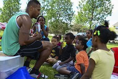
Community Events
Connect with the neighborhood at park events..
Wetlands
Landscaping elements at the park incorporate the natural environment through the use of wetlands and filtration basins that beautify the area and purify storm water runoff through Bassett Creek into the Mississippi River.
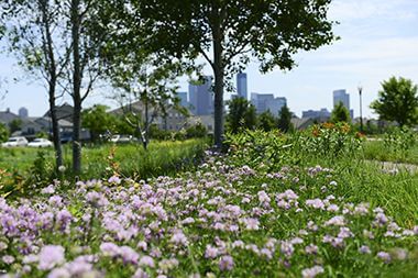
Sumner Park Flowers
Landscaping elements at the park incorporate the natural environment through the use of wetlands and filtration basins that beautify the area and purify storm water runoff through Bassett Creek into the Mississippi River.
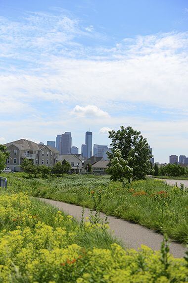
Walking Paths
Interpretive features at Sumner Field connect park goers to the area’s history.
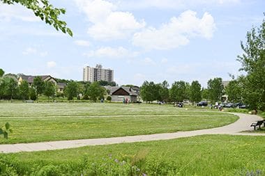
Sumner Greenspace
Interpretive features at Sumner Field connect park goers to the area’s history.
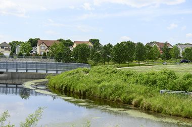
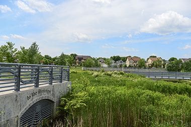
Bassett Creek
As the city developed, the creek was diverted to underground pipes to lessen the potential for flooding. When Sumner Field was redeveloped in 2005, the creek was integrated into the park.
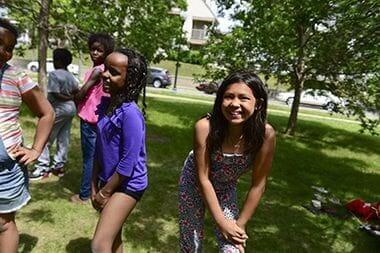
Sumner Park Community Events
Connect with the neighborhood at park events..
Park Board Announcements
There are no announcements at this time. Please check back soon.