


Father Hennepin Bluff Park
Address
420 Main St. SE
Minneapolis, MN 55414
Plan Your Route
Contact
Phone: 612-230-6400
Email: info@minneapolisparks.org
Park Hours
6 am-midnight in developed areas
6 am-10 pm in undeveloped areas
Ordinance PB-2-33
Father Hennepin Bluff Park
Part of: Central Mississippi Riverfront Regional Park
Find a Recreation Center
Park Projects
This park will be affected by Stone Arch Bridge Repairs.
Features & Amenities
- Bandstand
- Drinking Fountain
- Grill
- Picnic Area
- Walking Path
A portion of the park is officially known as Phillip W. Pillsbury Park, and another half-acre of land on the bluff, Lucy Wilder Morris Park, was officially added to the park in 1989. More information about both Pillsbury Park and Lucy Wilder Morris Park can be found under the History tab.
Not finding what you’re looking for?
Search Parks & Destinations

Park Details
Size: 8.02 acres, including the 0.06-acre Lucy Wilder Morris Park
Neighborhood: Marcy Holmes
Service Area: Southeast
Walking path goes down to the edge of the Mississippi River.
Rentals & Permits
Annual Patron Parking Permit: Enjoy parking privileges in specially designated spaces at some of our most popular regional parks. View parking permit details.
Bandstand Reservations: Call 612-230-6400
Outdoor Use and Event Space: Learn how to reserve park space for corporate events, community celebrations, and more. Application [PDF]
History
Name: The park was named for Father Louis Hennepin, a Franciscan priest who was the first European to view St. Anthony Falls from the site of the park in 1680. Hennepin named the falls for his patron saint, St. Anthony of Padua. Hennepin was also the first European to make a record of viewing Niagara Falls.
A portion of the park is officially known as Phillip W. Pillsbury Park. The Pillsbury Company donated 2.4 acres of land to enlarge the park in 1981. The Pillsbury family, founders of the milling company, had been linked with Minneapolis parks from the earliest days of the park board. George Pillsbury was one of the Minneapolis businessmen who had been instrumental in pushing the Minneapolis Board of Trade to draft legislation for presentation to the state legislature to create the Minneapolis Board of Park Commissioners in 1883. His brother John Pillsbury, a former governor of Minnesota, was one of the first twelve park commissioners appointed by the legislation. It was John Pillsbury who proposed to the new park board that it hire landscape architect Horace Cleveland to create a plan for the fledgling park system. The result was Cleveland’s “Suggestions for a System of Parks and Parkways for the City of Minneapolis,” presented to the park board in June 1883.
John Pillsbury’s son, Alfred, also became a park commissioner and was president of the park board in the 1930s.
Acquisition and Development
The initial land for the park was acquired by the park board in 1977. It was the first park land to be acquired for what would become Central Riverfront Regional Park.
The land was acquired for about $800,000 with funds provided by the state legislature through the Metropolitan Council. The land had been part of the initial, and least controversial, part of the plan for the central riverfront created by the Riverfront Development Coordinating Board (RDCB), a joint effort of the park board, city council and the Minneapolis housing authority, chaired by park commissioner Ole Olson. The RDCB envisioned the bluff left in its natural state with trails down to and along the river. The RDCB’s plan also included Hennepin Island and the east channel of the river, but those parts of the plan have never been completely implemented. The plan for the area was intended to evoke images of Huck Finn. The bluff park was initially developed and opened in 1979. It was designed by famous landscape architect Hideo Sasaki.
In 1981 the park was augmented by a donation of 2.4 aces of land from the Pillsbury Company in honor of Phillip W. Pillsbury.
Another half-acre of land on the bluff, Lucy Wilder Morris Park, was officially added to the park when title to the land was turned over to the park board by the Hennepin County Historical Society in 1989. The park board had been maintaining Lucy Wilder Morris Park, however, since 1931 under an agreement with and funding from the Daughters of American Colonists.
The finishing touch to the park, which gave it its present appeal, was the agreement to convert the Stone Arch Bridge to a pedestrian and bicycle path in 1993. The bridge connects the eastern edge of the park with the west bank of the river and Mill Ruins Park.
Proposals to convert the east channel of the river between Father Hennepin Bluff Park and Hennepin Island into a whitewater park have been under consideration for years. The sticking point has always been the source of funding for that development.
In 2011 the stairs from Main Street down to Hennepin Island and the river were repaired.
In 2014 the inaugural Owamni: Falling Water Festival was held at the park. The annual festival celebrates indigenous Minnesota cultures with art, music food and film.
In 2023 a large park renovation was completed. It included a new stage and bathroom building next to the Stone Arch Bridge, upgraded paths, park entry points and lighting, and better stormwater management and landscaping.
History through 2008 written by David C. Smith, with updates from 2009 to present written by MPRB.
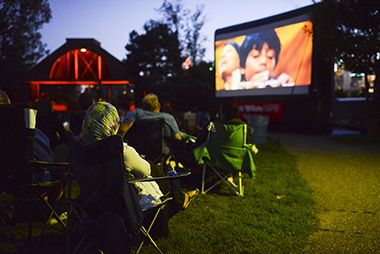
Movies in the Parks
Every summer you can enjoy a series of free music and movies in the park at Father Hennepin Bluff Park and several other locations throughout the park system.
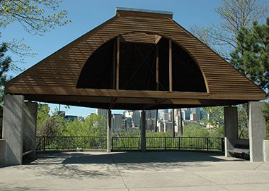
Bandstand
Come to the bandstand in the summer for music and movies in the park.
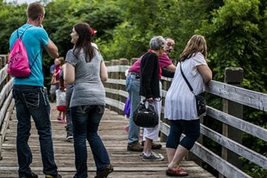
Walking Paths
Enjoy a shady stroll along Father Hennepin Bluff Park's paved walking trails or head down to the river on the footpaths and bridges.
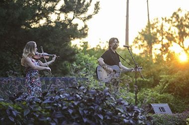
Music in the Parks
Every summer you can enjoy a series of free music and movies in the park at Father Hennepin Bluff Park and several other locations throughout the park system.
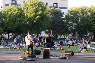
Music in the Parks Concert
Every summer you can enjoy a series of free music and movies in the park at Father Hennepin Bluff Park and several other locations throughout the park system.
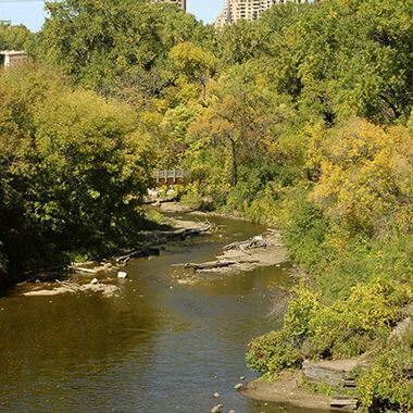
Father Hennepin Bluff Park
Take in the beauty of the Mississippi River from close up and enjoy a unique view of St. Anthony Falls.
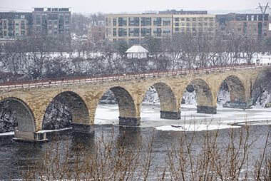
Stone Arch Bridge in Winter
Snow and ice don't stop park goers from enjoying the outdoors!

Movies in the Parks Audience
Every summer you can enjoy a series of free music and movies in the park at Father Hennepin Bluff Park and several other locations throughout the park system.

Historic Main Street
Father Hennepin Bluff Park is located next to Historic Main Street, which hosts events nearly every weekend during the summer.
Park Board Announcements
There are no announcements at this time. Please check back soon.