


Historic Main Street Park
Address
420 Main St. SE
Minneapolis, MN 55414
Plan Your Route
Contact
Phone: 612-230-6400
Email: info@minneapolisparks.org
Park Hours
6 am-midnight in developed areas
6 am-10 pm in undeveloped areas
Ordinance PB-2-33
Historic Main Street Park
Part of: Central Mississippi Riverfront Regional Park
Find a Recreation Center
Features & Amenities
- Biking Path
- Picnic Area
- Walking Path
Not finding what you’re looking for?
Search Parks & Destinations
Good to Know
On-street parking kiosks are available.
Long-Range Vision Plans
This park will be affected by a completed park or service area long-range vision plan. View Long-Range Vision Plans.

Park Details
Size: 5.61 acres
Neighborhood: Nicollet Island-East Bank and Marcy Holmes
Service Area: Northeast/Southeast
Historic Main Street is located between the Hennepin Avenue bridge and Father Hennepin Bluffs Park on the East side of the Mississippi River. The area was originally part of the town of St. Anthony before it merged with Minneapolis.
Rental & Permits
Outdoor Use and Event Space: Learn how to reserve park space for corporate events, community celebrations, and more.
History
Name: The name is descriptive. The street was the original Main Street of the town of St. Anthony.
Acquisition and Development
The street and the adjacent river bank were turned over to the park board by the city in
1979 at the same time that the park board acquired its first land on Nicollet Island. The acquisitions were part of a plan developed in 1977 for the central riverfront by the Riverfront Development Coordinating Board, a joint effort of the park board, the city council and the Minneapolis Community Development Agency. The historic street linked Father Hennepin Bluff Park downstream with the developments planned for Nicollet Island and Boom Island farther upstream.
Main Street was linked to Nicollet Island in 1987 when Hennepin County floated a span of the Broadway Avenue Bridge, which was being replaced, downriver to connect Merriam Street on Nicollet Island to Main Street.
The entrance to Water Works, which provides access to the edge of St. Anthony Falls, is located off Main Street.
History through 2008 written by David C. Smith, with updates from 2009 to present written by MPRB.

Hot Dam 5k
Connect with the neighborhood at park events.
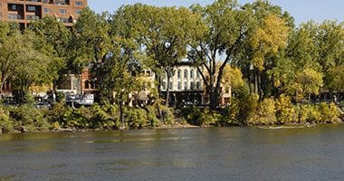
Historic Main Street Riverfront
Historic Main Street is located between the Hennepin Avenue bridge and Father Hennepin Bluffs Park on the East side of the Mississippi River.

Hot Dam 5k Starting Line
Connect with the neighborhood at park events.
Park Board Announcements
There are no announcements at this time. Please check back soon.