


Off-Road Cycling Trails
Location
Theodore Wirth Pkwy. & Cedar Lake Pkwy.
Minneapolis, MN 55411
Trail Conditions
Trails are open only when they are not muddy or melting. Follow @trailconditions on Twitter, or connect with the Android App or the Apple App.
Trails may be used during the winter months for fatbiking when trail is frozen. Do not ride or walk on slushy or melting trails
Contact
Phone: 612-230-6400
Email: info@minneapolisparks.org
Park Hours
6 am-midnight in developed areas
6 am-10 pm in undeveloped areas
Ordinance PB-2-33
Plan Your Route
Trail Partners
Off-Road Cycling Trail
Trails & Activities
Main off-road cycling loops from north to south:
45 North: Approximately 1.5 miles of intermediate level single track. This is our fast and flowing single track with plenty of rollers. When you get to the far north side of this trail you actually cross directly over the 45th parallel!
- Access this trail off of Theodore Wirth Parkway when heading north of the old chalet and just after you cross over the Bassett Creek bridge. It is on the west side of the parkway but the east side of Bassett Creek.
- 45 North trail map and conditions
Conundrum: Approximately 1.25 miles of intermediate and advanced level single track that starts with one of the biggest climbs in the park.
- Access this trail just north of the old golf chalet off of the parkway just before you head north over the Bassett Creek bridge.
- Conundrum trail map and conditions
Mountain Bike Skills Area: Three skill level loops make this a great spot for any rider to develop their skills.
- The skills area is directly north of the Trailhead building
- Mountain bike skills area map and conditions
Area 36: Approximately 2.5 miles of beginner and intermediate level single track that is physically demanding but technically easy.
- Access this trail just to the west of the front entrance of The Trailhead.
- Area 36 trail map and conditions
Back 40 Loop: NEW, EXPANDED EXPERT SECTION! Approximately 3.3 miles of single track, 2.8 miles are intermediate difficulty, 0.5 miles are expert difficulty
- Accessible by bike off of the Luce Line Trail that runs easterly from Theodore Wirth Parkway, just south of the Wirth Par 3 Club House
- Back 40 Loop Map and Info
South Loop: Approximately 0.8 miles of single track, 0.8 miles are intermediate difficulty
- Accessible by bike from Theodore Wirth Parkway, just south of the railroad track bridge and from the south near Olson Memorial Highway
- South Loop Map and Info
Glenwood Spur: Approximately 0.9 miles of single track, 0.9 miles are intermediate difficulty
- Accessible by bike from the Northwest corner of the Theodore Wirth Parkway and Glenwood Avenue and off the parkway’s paved trail 0.25 miles further north
- Glenwood Spur Map and Info
Southwest Loop: Approximately 1.9 miles of single track. 1.9 miles are intermediate difficulty.
- Accessible by bike from the Southwest corner of the Theodore Wirth Parkway and Glenwood Avenue, and from the Northwest corner of Theodore Wirth Parkway and I-394
- Southwest Loop Map and Info
Brownie Lake Loop: Approximately 1.5 miles of single track. 0.75 miles are intermediate to expert difficulty, 0.25 are expert difficulty, and 0.5 are extreme difficulty.
- Accessible by bike from the Southwest corner of the Theodore Wirth Parkway and I-394
- Brownie Lake Loop is an advanced trail with steep rock climbs and descents, and technical features including drops. This trail requires expert skills to ride safely.
- Brownie Lake Loop Map and Info
Good to Know
Minneapolis Off-Road Cycling Advocates (MOCA) volunteers monitor and maintain the off-road cycling trail.
Open to cyclists, hikers, trail runners, and snowshoers.
Parking available at Wirth Lake Beach.
Trails are closed to all users when it is wet. If your foot or tire leaves a track or footprint in the tread, the trail is closed.
Trail/Parkway Details
Rentals & Permits
Outdoor Use and Event Space: Learn how to reserve park space for corporate events, community celebrations, and more. Application [PDF]
Penalty for Building Unofficial Trails: Construction permits are required by the MPRB for any projects within the park system, including trail building. MOCA obtained a construction permit, and the trails it constructed in accordance with the permit are sustainable and meet the MPRB’s risk management considerations. Engaging in construction within the park system, i.e., building unofficial trails can result in a $1,000 fine per incident.
About
We are dedicated to using the latest techniques for building fun and sustainable trails. Sustainable natural surface trails are constructed from native soils and come in the form of walking paths, running paths, nature trails, and mountain bike trails.
The natural surface trails within Theodore Wirth Park officially opened in 2005 as a sanctioned facility in the Minneapolis park system.
The trail was originally a demonstration project to prove the sustainability of off-road trails in the system. The project demonstrated that a sustainable, safe, and low-maintenance trail can protect natural resources, challenge off-road cyclists, and be compatible with other park uses.
The trail was developed according to the best practices of Minneapolis Off-Road Cycling Advocates (MOCA) and Minnesota Off-Road Cyclists(MORC). The partnership between these two groups and the Park Board is essential to the long life of the existing trails and the creation of new trails.

Off-Road Cycling Trails at Theodore Wirth Regional Park and Brownie Lake Park

Biker Duo on a Winter Off-Road Cycling Trail

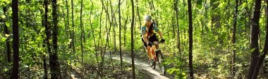
Biker on an Off-Road Cycling Trail

Off-Road Cycling Trail in the Winter

Off-Road Cycling Trails Vary from Beginner Level to Extreme Difficulty

Sustainable Natural Surface Trails are Constructed from Native Soils

Winter Biker on an Off-Road Cycling Trail

Group of Off-Road Cyclers
Off-Road Cycling Trail

Volunteers Monitor and Maintain the Off-Road Cycling Trails
Park Board Announcements
There are no announcements at this time. Please check back soon.