


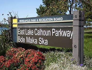
Bde Maka Ska Park
Address
3000 Bde Maka Ska Parkway
Minneapolis, MN 55408
Plan Your Route
Contact
General: 612-230-6400
Email: info@minneapolisparks.org
Park Hours
6 am–midnight in developed areas
6 am–10 pm in undeveloped areas
Ordinance PB-2-33
Bde Maka Ska Park
Part of: Minneapolis Chain of Lakes Regional Park
Find a Recreation Center
Park Projects
This park will be affected by park improvement projects. View the Bde Maka Ska Boat Launch and Sailing Center Relocation Predesign, Bde Maka Ska/Mahpiya Wicasta Public Art & Site Improvements, and Bde Maka Ska Shoreline Repairs.
Features & Amenities
- Archery
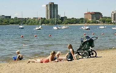
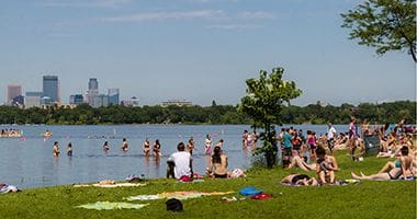
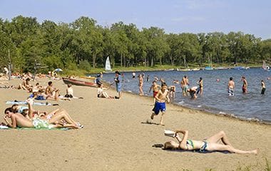
- Beach
- Biking Path
- Boat Dock
- Drinking Fountain
- Fishing Pier
- Pay Parking Lot
- Picnic Area
- Restroom Facility
- Soccer Field
- Softball Field
- Volleyball Court – Sand
- Walking Path
- Well
Not finding what you’re looking for?
Search Parks & Destinations
Good to Know
Beaches:
Canoe, kayak, bike, boat, and paddle board rentals offered through Wheel Fun Rentals
A pay parking lot is available.
![]()
Your NPP20 money at work:
Maintenance is increasing at all neighborhood parks, thanks to additional annual funding from the 20-Year Neighborhood Park Plan (NPP20). This initiative also funds ongoing rehabilitation and major project to restore neighborhood parks and help address racial and economic equity.
Park Details
Size: 518.86 acres
Trails: Pedestrian (3.1 miles), Bike (3.19 miles)
Neighborhood: Cedar-Isles-Dean, East Harriet, ECCO, Linden Hills, and West Calhoun
Service Area: Southwest
Lake Info
Bde Maka Ska is monitored as part of the Minneapolis Park & Recreation Board’s (MPRB) lake water quality monitoring program.
Click here for MPRB lake monitoring info
The Minnesota Department of Natural Resources has details regarding the size, shore length, depth, and other features of the lake.
Rentals & Permits
Annual Patron Parking Permit: Enjoy parking privileges in specially designated spaces at some of our most popular regional parks. View parking permit details.
Athletic Rentals: To reserve a field, court, or rink visit our athletic permit page.
Canoe/Kayak Storage Rack Permit: An annual permit allows you to store your canoe or kayak. View canoe/kayak permit details.
Outdoor Use and Event Space: Learn how to reserve park space for corporate events, community celebrations, and more.
Parkway Use: You must obtain a permit for special use of the parkway including closures, and dumpsters, trucks, limousines or carriages on the parkway. View parkway permit details.
Sailboat Buoy Permit: An annual permit allows you to store your sailboat on the lake. View sailboat buoy permit details.
Bike and Watercraft Rental: Rent through Wheel Fun Rentals.
Beach Group Use Permit: Apply for a free permit to ensure we can accommodate your birthday party or group of 10 or more at the beach. Visit Beach Group Use Permit for details.
History
Name: On January 29, 2018, Bde Maka Ska (pronounced “b-day ma-KHA skah”) became the official name of the lake previously known as Lake Calhoun, following county and state approval of a request to change the lake name. Bde Maka Ska translates to “White Earth Lake” in the Dakota language.
The MPRB does not have the authority to officially change a lake name. Following two years of community engagement, MPRB Commissioners unanimously approved the Calhoun/Bde Maka Ska-Harriet Long-Term Plan on May 3, 2017, which included an Equity Subcommittee recommendation to support restoration of the name Bde Maka Ska.
Following approval of the master plan, the MPRB submitted a petition requesting the lake name change to the Hennepin County Auditor. A public hearing on the name change was held by Hennepin County on Oct. 17, 2017 and Hennepin County Commissioners approved a resolution requesting the name change on Nov. 28, 2017. Then the County submitted the resolution to the Minnesota Department of Natural Resources (DNR).
The DNR announced its approval of the name change on Jan. 18, 2018. The lake name change became official in Minnesota on Jan. 29, 2018, after DNR approval was recorded by Hennepin County and published in the State Register. The Minnesota Supreme Court ruled the DNR had the authority to change the lake name on May 13, 2020.
Names of four park road or parkways bearing the name “Calhoun” were changed to “Bde Maka Ska” when Minneapolis Park and Recreation Board Commissioners approved an ordinance amendment at its meeting on Aug. 21, 2019.
Park entrance signs were previously updated on Oct. 2, 2015 to include both Lake Calhoun and Bde Maka Ska as a public education effort and as a way to honor the Dakota name.
The lake had been named for John Caldwell Calhoun, U.S. Senator, vice president of the United States, and Secretary of War under James Monroe. As Secretary of War, Calhoun ordered Colonel Leavenworth to establish a fort in the region, which became Fort Snelling.
Indigenous History
In 1829, Dakota people created a village on the shore of Bde Maka Ska. The name of the village was Heyáta Othúŋwe, which can be translated as “The Village Set Back (from the Mississippi River).
A Dakota leader named Mapíya Wičhášta (Cloudman) established the village in order to adopt new agricultural methods. For the next 10 years, farmers at Heyáta Othuŋwe were successful enough to feed not only themselves but neighboring Dakota villages. After ten years, the village avoided ongoing conflict with Ojibwe people by relocating to “Oak Grove,” which would become Bloomington, Minnesota
For more information on Dakota history at Bde Maka Ska, go to bdemakaska.net.
Acquisition
One of the primary reasons the park board was created in 1883 was to create parks at Bde Maka Ska and Lake Harriet. In 1880, three years before the park board was created by the state legislature and approved by the voters of Minneapolis, Charles Loring, who would come to be known as the “Father of Minneapolis Parks,” lobbied successfully with a railroad company not to place its new track too near the north shore of Bde Maka Ska. “The cordon of beautiful lakes encircling our city,” he said at the time, “has long been a pride of the city and our people have for many years cherished a hope…that in the near future they would establish in the vicinity of the lakes…a grand system of parks with wide connecting boulevards extending around those lakes.”
The importance of the lake to park plans was highlighted at the time the voters of Minneapolis were asked to make a decision on the creation of a park board. During the debate over the proposed “Park Act” in 1883 the Minneapolis city council passed a resolution that the city needed many things more than “spending money around Lake Calhoun.”
Despite the council’s objection to an independent park authority, Minneapolis voters approved the Park Act in April 1883. One of the new park board’s first actions was to hire landscape architect Horace Cleveland to create a plan for the new park system. His plan, which proposed parkways to connect points of natural beauty, included a parkway all the way around Lake Harriet, then along the south and west shores of Bde Maka Ska connecting to Lake Street, and running along the north shore of the lake. The only part of the Bde Maka Ska shore not included in Cleveland’s proposed system of parkways was the shoreline on the east side of the lake from Lake Street to Lakewood Cemetery.
Ironically, that eastern shore was the first land the park board acquired at Bde Maka Ska. It wouldn’t acquire the south and west shores for another 25 years. It wasn’t that the new park commissioners, with Charles Loring as president, didn’t try to follow Cleveland’s plan; they did. In late 1883 the board designated the entire shore of Lake Harriet and the south and west shores of Bde Maka Ska for acquisition—as well as a parkway on Lake Street from Bde Maka Ska to the Mississippi River. But many of the park board’s early plans were blocked by the high cost of the land it wanted.
The first land the park board purchased was for neighborhood parks—Loring, Farview, Logan and Riverside parks—and little money was left to buy lake shores and river banks. It bought some land on the east bank of the Mississippi River near the University of Minnesota campus, but couldn’t afford to buy more and eventually sold some of those lots. The land it wanted around Lake Harriet was valued at nearly $300,000, way beyond its budget, and the board abandoned that acquisition until Henry Beard, James Merritt and Charles Reeve came forward with an offer to donate that land. (The courts later decided that William King owned some of that land, but King honored their offer of the lake shore to the park system. See Lake Harriet for more of that story.) The park board also found the price tag for land for a parkway on Lake Street from Bde Maka Ska to the river too high and abandoned that plan.
In the face of those failures, in 1885, the park board determined to buy a shorter stretch of the Bde Maka Ska shore, the shortest connection from Lake of Isles to Lake Harriet. Lake of the Isles, largely a swamp, hadn’t figured in early park planning at all, but following Charles Loring’s success in getting most of Lake Harriet donated to the park system, he found that many landowners around Lake of the Isles were also willing to donate lakeshore for a parkway. With Lake Harriet and Lake of the Isles incorporated into the park system at little cost, the park board needed a way to connect those lake shore parkways by establishing a parkway around Bde Maka Ska. The east shore was the logical way to connect them; it was the shortest route.
Even then it was a difficult acquisition, but in December 1885 the park board designated a strip of land along the lake for purchase by condemnation. The land was appraised at nearly $30,000, which Loring wrote was “in the opinion of the Board quite beyond the actual damages.” Yet Loring and others considered the land essential to acquiring a parkway that would run from Loring Park to Lake of the Isles, then to Lake Harriet. Loring wrote in his diary of the effort to convince other park commissioners to spend the money. Loring wrote that he and fellow park commissioner, Eugene Wilson, took another commissioner, John Oswald, out on Bde Maka Ska in a rowboat to show him the beauty of the lake and its vital connection to the other lakes. Oswald was won over and voted to pay the price for the first park land at Bde Maka Ska. The cost of the acquisition was levied against property in the area.
The park board took another step toward acquiring Bde Maka Ska in 1887. The park board reported then that it had secured a 1200-foot strip of the northwest shore of Bde Maka Ska through a donation by Joseph Dean and others of land extending from the west side of Lake of the Isles to Bde Maka Ska. Most of that land became Dean Parkway, but included part of the shore of Bde Maka Ska. That donation was not completed until 1892, when the park board finally complied with the terms of the donation by constructing Dean Parkway through that land.
Joseph Dean’s heirs had made possible another important development at Bde Maka Ska when, in 1891, they sold to the park board for $22,000 the land that connected the east sides of Lake of the Isles and Bde Maka Ska. This was at the time the “missing link” in the parkway system, the only gap in the Loring Park-to-Minnehaha Creek parkway around the lakes.
Despite owning only two stretches of shoreline at Bde Maka Ska, the idea of acquiring the rest of the lake as a park didn’t go away. Two of the great visionaries in Minneapolis park history continued to campaign for acquiring all of the lake. Charles Loring in 1893 and William Folwell in 1898 urged the park board to acquire the entire lakeshore. The completion of a parkway all the way around Bde Maka Ska, Folwell wrote, “commends itself to everyone.”
In 1907 the park board took another important step in securing title to the entire lake shore; it purchased most of the land between Lake of the Isles and Bde Maka Ska. The purchase completed park board ownership of the north shore of Bde Maka Ska. An additional benefit of the purchase was that it enabled the park board to get rid of the ice houses on the north shore of the lake, which were considered to be an eye sore. The ice houses were used to store ice cut from Bde Maka Ska in winter for sale throughout the year.
The issue of acquiring the south and west shores of the lake remained open and many landowners along the shore offered to donate strips of shoreline to make possible a drive around the entire lake. In the 1907 annual report the board advocated the acquisition of the remaining shore of Bde Maka Ska, in part, out of consideration for those land owners who already had offered to deed shore rights to the park board for a parkway. In 1907 and 1908 the park board accepted deeds from at least seven property owners on the south and west sides of the lake. In June of 1908 the park board designated for purchase the remaining land that had not been donated. The entire shore of the lake was finally acquired in 1908, and in its 1909 annual report the park board for the first time added the 461 acres of the lake to its inventory.
Curiously, in the inventories of park lands the park board published in its annual reports into the 1960s, the board never included the estimated value of the donations of land around Bde Maka Ska—from Joseph Dean in 1887 to the Minikahda Club and others in 1908—as it did for other park properties. The total cash cost of acquiring Bde Maka Ska over more than 20 years was just under $130,000, a pittance compared to the inestimable value of the lake to the people of the city over the years, but nearly double the price of any other lake acquired by the park board.
Development
Less than two years after acquiring Bde Maka Ska’s eastern shore and building a parkway along the area it referred to as Calhoun Terrace, the park board began making provisions for recreational use of the lake. In 1887 the park board provided recreation at the lake by creating a skating rink, a racetrack on the lake for horses, which was later moved to Lake of the Isles, and a toboggan slide. In the summer of 1887, the board also sold a concession to rent boats from park property on the east side of the lake.
Public demand led the park board to erect a temporary bath house on Bde Maka Ska in 1890, the first recreation building of any kind operated by the park board. The first bath house was for men and boys only, but the next summer the park board added a separate bath house for women and girls. 1891 was also the first year that the Minnesota Fish Commission stocked fish in city lakes and proposed maintaining the lakes as fish hatcheries.
The first electric lights were installed at the lake in 1892, at the same time they were installed at Minnehaha Park and in Interlachen (William Berry) Park between Lake Harriet and Bde Maka Ska. (Electric lights had already been in use at Loring Park for several years.)
The bath house at Bde Maka Ska was the first building the park board ever operated, even though it was removed from the beach in winter. It was also the site of the first recreation instruction on park property. In 1895 the board granted permission to Mabel Clark and Harry Feagles to give swimming lessons at the bathhouse. At the same time the park board approved the purchase of swimming suits—10 for women, 25 for men—for rental at the beach. The board also accepted the offer of Dr. Avery to teach bath house employees how to resuscitate drowning persons.
A new, but still portable, bath house was built on Bde Maka Ska in 1901 to designs by architect and park commissioner Harry Jones. The cost of building the bath house was paid by the city council. (The council also paid for the construction of a bathhouse on the Mississippi River at Riverside Park.)
A Marriage of the Lakes
In July 1911 Bde Maka Ska was “married” to Lake of the Isles with the opening of a channel between the lakes. The opening of the water connection between the lakes on July 5 was the focus of a week-long celebration in the city. The celebration featured canoe races, fireworks at Lake Harriet and a play about the city’s history that ran for three nights at Loring Park to crowds of 25,000 each night. A cartoon in a Minneapolis newspaper depicted the event as a wedding of the lakes, and indeed water from both lakes were mixed in a “loving cup” and poured into the canal to symbolize the union of the lakes.
The event was the culmination of years of planning. The idea of connecting the lakes with a canal was at least twenty years old. From the time the park board first began negotiations with the Dean family to acquire the land between the eastern shores of the lakes in the 1880s, the possibility of linking the lakes had been mentioned. When the acquisition of that land was finalized, the park board’s 1892 annual report celebrated the purchase not only for it being the last link in the parkway system from Loring Park to Minnehaha Creek, but for its possible use as a “desired water connection between the lakes.”
When noted landscape architect Warren Manning was hired to review plans for the entire park system in 1899, he treated the connection of the two lakes as a given in his report. But it wasn’t until 1905, in response to petitions from citizens to connect the lakes at a depth that boats could pass between them, that the board made its first commitment to proceed with the project.
Park superintendent Theodore Wirth, who was hired in 1906, presented the first plans for a Lake of the Isles-Bde Maka Ska water connection in the 1907 annual report. As Wirth began improving the often-flooded parkway on the west side of Lake of the Isles in 1907, which eventually led to the reshaping of the lake and elimination of wetlands and swamp there, the board approved plans and cost estimates—about $100,000—to create the channel between the lakes. Wirth’s original plan was eventually modified considerably, eliminating a harbor he had proposed between the lakes.
The plan to link the lakes was followed in 1908 by a detailed plan for the development of all the newly acquired land between Lake of the Isles and Bde Maka Ska. That plan included separate roadways for Lake Street and a parkway next to the lake. Park board president Jesse Northrup noted that the parkway was made possible due to the street railway company “cheerfully” moving its track further from the lake, at a cost of $25,000 to the company, to make space for a parkway. The street railway tracks had previously run along the edge of the water between Lake Street and the lake.
One of the great challenges—and expenses—of the water link between the lakes was building the bridges over the canal for railroads and streets. A design competition, with a first prize of $800, was held for those bridges, which drew entries from around the country.
Bde Maka Ska Beach House and North Shore Development
The park board had employed a dredging company from 1907 to 1911 to dredge and reshape Lake of the Isles, especially the western shore. In 1911 the dredges were moved across Lake of the Isles to dig the channel between the lakes and when that work was completed they moved into Bde Maka Ska to work on the north and west shores. ( The dredges would return to Lake of the Isles two years later to begin work on the Kenilworth Lagoon connecting Lake of the Isles to Cedar Lake.) The goal was to create a beach on the strip of land originally donated by the Deans in the northwest corner of the lake and to construct a firm road bed for a parkway along the west shore.
In 1910, the year before the channel between the lakes was completed, Theodore Wirth had presented plans for the development of much of the rest of the land around Bde Maka Ska. It was a project he had opposed when he had arrived in Minneapolis four years earlier.
Wirth had initially taken the position in 1906 that a drive on the west shore of Bde Maka Ska was “not very pressing,” and “simply a repetition of what we already have several miles of—a shore drive.” Wirth wrote that he thought it was better to improve existing parkways to reduce the cost of maintaining them, than to add parkways. Wirth also suggested that a better location for a West Calhoun parkway would be on the hill through the lawn in front of the Minikahda Club, should that club ever relocate. That drive, he wrote, would provide a view of the lake and the city of “such scenic beauty that it is almost a crime to pass it unnoticed.”
With the acquisition of the west shore of the lake in 1908-1909, however, the creation of a parkway there became a given, partly because a condition for the donation of some of the shore was that a parkway be built. And it didn’t appear that the Minikahda Club would be relocating anytime soon.
Wirth’s 1910 plan proposed filling in the shore near Xerxes Avenue and the wetlands west of Xerxes to create a meadow. His plan for the northwest corner of the lake included a boat harbor dug into the lowlands. That plan was modified in 1911 and the area eventually was filled instead of dredged creating what is now used as a soccer field, the only playing field near the lake. (Contrary to popular belief, the park board never owned the land at the southwest corner of the West Calhoun Parkway and Lake Street intersection. In 1916 the park reported that the purchase of 93 acres there was pending, but the deal was never completed.)
With plans in hand for the northern and western shores of the lake, and the channel to Lake of the Isles completed, the park board began construction of a modern beach house, a changing room for swimmers, in 1911. The old temporary beach house on the northeast corner of the lake was divided into two sections; one was moved to Lake Nokomis and the other to Glenwood (Wirth) Lake. A boathouse was built on the old bath house location.
The new house on a new beach, which was created by dredging sand from the lake bottom, was completed in 1912 and was an immediate success. Demand for the use of the changing rooms at the beach house was so great that swimmers were limited to leaving their clothes in a changing room for only an hour, despite the capacity to accommodate 1,250 people. Soon, the park board replaced many of the larger changing rooms with lockers to accommodate more people. Lines of swimmers waiting to use changing rooms and lockers stretched for blocks on hot summer days.
The beach house was so popular that many people, Charles Loring and Theodore Wirth among them, advised the park board to acquire the land across Lake Street from the beach to prevent commercial development there. It was the only piece of land between Lake of the Isles and Bde Maka Ska that the park board didn’t own. Unfortunately, the park board never did acquire that land, which would lead nearly 80 years later to a battle to prevent the development of high-rise residential buildings across the street from the lake. That fight eventually produced a new city ordinance limiting the height of buildings near the lakes.
The story of the early development of Bde Maka Ska underscores the challenges of creating parks, especially in an urban setting, with streets and railroad tracks to contend with. The cost of development far exceeded the cost of the land—an experience repeated many times in the history of Minneapolis parks. The cash cost of acquiring Bde Maka Ska, without the value of donated land, was less than $130,000. But the park board spent more than $300,000 developing only the northern shore to uses the public wanted, from canal to parkway to bathhouse. And that was before the park board incurred the continuing costs of operating and maintaining the land and facilities.
West and South Shore Development: Dry Land, Deep Water and No Swamps
As development of the north and west shore parkways and facilities were still being planned, the park board also focused on the southern shore of the lake. As part of the consideration of linking all the southwestern lakes, the park board also looked at creating a water connection between Lake Harriet and Bde Maka Ska. In 1909, Wirth presented options for that connection. The challenge was that Lake Harriet was seven feet lower in elevation than Bde Maka Ska. Any connection between those lakes would have required the construction of locks. One option Wirth presented was a canal that would have run south from Bde Maka Ska along what is now Washburn Avenue through Linden Hills, turning east at 43rd Street to roughly Thomas Avenue, then following Thomas through Dell Park to meet Lake Harriet at 45th Street. The best option for the canal, Wirth noted, was through Lakewood Cemetery. Wirth considered none of the plans very practical and they were never apparently given serious consideration.
But the plan for a canal through the wetlands south of Bde Maka Ska perhaps did give an idea to the Lake Harriet Commercial Club. In 1909 the city council had refused a request from the group to fill the wetlands lying along what is now Washburn Avenue, so in 1910 the club asked the park board to acquire that land from Bde Maka Ska to 43rd Street between Xerxes and Washburn avenues as a park. The park board declined, after surveying the area, due to a shortage of funds.
But the issue came up again a few years later as the park board considered building permanent parkways around the south and west shores of Bde Maka Ska and improving Interlachen (William Berry) Park nearby.
In January 1916 the park board designated for acquisition 65 acres of land south of Bde Maka Ska for a “lagoon”—also called “South Bay”—from Bde Maka Ska to 42nd Street between Xerxes and Upton avenues. The proposed acquisition and development of “South Bay Drive” was one of the most contentious issues for the park board for many years. Over the objections of some commissioners, who felt the cost of the project was too high and ignored other priorities, especially playgrounds, in other parts of the city, the park board stuck with its plans to add substantially to the size of Bde Maka Ska by dredging a bay.
The sticking point finally was the cost of the project and how it would be paid for. The park board proposed to assess the cost to property owners: two-thirds to property in the area and one-third to property throughout the city. The total estimated cost of the lagoon and parkway around it was $242,000 out of a total of nearly $700,000 proposed for all the improvements recommended at Bde Maka Ska and Lake of the Isles and William Berry Park.
The landowners in the vicinity filed a law suit challenging the park board’s authority to assess their land for the cost of the improvements. Before the suit was determined in court, the park board annulled all previous proceedings on the project due to a rapid rise in estimated costs during the inflationary time following World War I. It wasn’t until 1922 that the Minnesota Supreme Court ruled in favor of the park board and its authority to assess the costs of improvements on property owners. By then “South Bay” had become too expensive and the park board never reconsidered that part of the project.
However with the favorable court ruling the park board did begin the dredging and reshaping of the southern shore of the lake in 1923. In his 1923 annual report Wirth wrote that the weedy, shallow, unnavigable and unsanitary water on the southern shore of the lake had been eliminated. The area of water was reduced by ten acres, but all of it was then navigable, according to Wirth. The reason for the dredging was not just to eliminate swamp, however. Solid ground was needed to construct a permanent parkway and that ground was built up, as it had been at Lake of the Isles years before, with fill dredged from the lake.
The dredging and filling along the shore was not welcomed by all. Park board president William Bovey acknowledged complaints in the 1924 annual report, when he noted the natural beauty of swamp and shallow water, but claimed that from a standpoint of “sanitation and utility” the landscape had been improved. Of the wetlands that were filled, Bovey wrote that “such natural conditions cannot be maintained on park properties in residential districts.” (The shores of Bde Maka Ska were not the only land converted to drier conditions in the vicinity at the time. Also in 1923 a 3,600-foot pipeline was built from Linden Hills Park to Bde Maka Ska to drain that land for park development.)
The next year, as work continued at Bde Maka Ska, Wirth reported another 26 acres of land were claimed from water leaving “no shallow, weed-blocked, mosquito-breeding water areas.” Water was dredged to a navigable depth or filled to create lawns, ball fields and parkway. The dredging and filling and road construction were completed in 1925.
The improvements included the addition of beaches on the south and east shores of the lake. These additional beaches addressed a growing concern by Wirth and the park board as more people acquired cars. As cars became more commonplace, people tended to drive to the lakes already in their swimming suits and therefore didn’t need to use the beach house changing rooms—nor limit their swimming to the beach there. The problem was that the park board couldn’t provide for the safety of swimmers everywhere on the lake. In 1921 Wirth proposed permitting swimming at other places on the lake in addition to the beach house. Where swimming was not authorized, Wirth suggested covering the shore with gravel and stones that would make walking and bathing in those areas nearly impossible. Adding a beach on the south side of the lake and another on the east side, ultimately addressed the issue in a more hospitable way.
Adding attractions to the designated beaches also may have helped reduce illicit swimming. In 1924 water toboggans were constructed on the beaches at both Bde Maka Ska and Lake Nokomis. They were precursors to today’s water parks. There is no record in park board proceedings of when or why the water toboggan slides—or the diving platforms—were taken down.
Maintenance, Management and New Amenities
Since 1925 few changes have been made to the basic shape of the lake and the road bed of the encircling parkway.
In 1930 a new shelter, toilet building and refreshment stand were built at the northeast corner of the lake near Lake Street and in 1940 the Works Progress Administration built shore protection walls along portions of the eastern shore.
Low water levels in the lakes in the 1950s–nearly two-and-a-half feet below normal–led to additional dredging of the channel between Lake of the Isles and Bde Maka Ska and eventually to dramatic measures to maintain water levels in the lakes.
In 1957 a pumping station was installed at Bassett’s Creek to pump water from that creek through a pipeline to Brownie Lake to raise water levels in the Chain of Lakes. But water levels remained low and the channel to Bde Maka Ska was too shallow even for canoes to pass through in the late 1950s.
The low water levels in the lake led to problems other than a reduction in canoeing. Weed growth accelerated with low water levels and in 1959 the park lakes, including Bde Maka Ska, were treated with sodium arsenite to control weeds. Efforts to raise lake levels by pumping water from Bassett’s Creek proved inadequate and in the 1960s a pipeline was built all the way to the Mississippi River to pump water into the lakes. The problem with that solution, however, was that the river water contained higher levels of phosphates than were considered healthy for the lakes. While pumping continued intermittently through the 1970s and 1980s, pumping from the river was not discontinued until the 1990s.
Attendance at the Bde Maka Ska beach house continued to decline from its peak in the 1920s. Attendance dropped dramatically during the Great Depression and was further hurt in the 1940s by polio scares. The aging facility was renovated in 1955 to make the outdated dressing rooms more appealing. Even with renovation, however, the era of changing into swimming suits at the beach was near an end.
Automobile traffic around the Chain of Lakes became a major issue in 1970 when a landscape architect hired by the park board to address the use of the lakes recommended closing the lake parkways to car traffic—and also proposed creating islands in Bde Maka Ska to add recreation space and visual appeal. The furor that followed put an end to discussions of changing the basic use of the lake and its encircling parkway, although subsequent changes were made to reduce traffic around the lakes. The parkway around Bde Maka Ska continued to carry two-way traffic.
The addition of recreation amenities on the lake shore has continued in more recent times. In 1979 two sand volleyball courts were built near the southwest shore of the lake and in 1985 a playground for small children was built on the east shore. A year later a walkway was created along the channel between Bde Maka Ska and Lake of the Isles to divert pedestrian and bicycle traffic under Lake Street.
The quality of the water in the lakes became an increasing concern in the 1970s. The first study of lake water quality was conducted in 1973. A second study in 1991 led to the creation of the Chain of Lakes Clean Water Partnership in 1994. Central to the issue of water quality in the lakes was storm water runoff from the lakes’ watershed. Exacerbating the problem was the removal seventy years earlier of the wetlands near the lake. In an effort to restore the filtering capacity of those wetlands, in 1998 the park board initiated a project to return the once-filled lawns southwest of Bde Maka Ska to wetland. Similar projects were also undertaken at Cedar Lake and Lake Nokomis.
New playground equipment was installed at the renovated north beach in 2009. On the opposite shore, the parking lot was renovated to improve circulation and water management. Permeable pavers and rain gardens helped prevent water run off. New lighting and signage also improved the experience of the park.
The year 2011 marked a return of a swimming dock or diving platform to the north beach, although the three-level platforms of the 1920s are unlikely to ever return.
In June 2012 the park board adopted emergency measures to prevent the spread of aquatic invasive species (AIS) to Minneapolis lakes. Since those measures were enacted, all boats entering Bde Maka Ska on a public launch are required to pass an AIS inspection. Despite thousands of inspections each year, two zebra mussels were discovered in the lake in September 2018.
Fishing docks were first installed at Bde Maka Ska in 1966. A new fishing dock was installed at the northwest corner of the lake in 2012 and the dock near 36th Street – the oldest in Minneapolis – was replaced in 2013 after a storm left it irreparably damaged.
Portions of the biking and walking trails around the lake were repaved with new accessible ramps in 2017. The World War I Mast Memorial at the northeast side of the lake was also redone with permeable pavers that year. In 2019, a large public art project that highlights Dakota culture and history at Bde Maka Ska was completed at the southeast side of the lake. It features a concrete walkway stamped with images of animals alongside their Dakota names, flanked by an ornate decorative railing depicting Indigenous plants. The walkway leads to a circular lakeside gathering place with large seating stones.
Park entrance signs were updated on Oct. 2, 2015 to include both Lake Calhoun and Bde Maka Ska as a public education effort and to honor the Dakota name for the lake. The Calhoun/Bde Maka Ska-Harriet Master Plan was approved in 2017. The 25-year plan for managing the two lakes and surrounding parkland included a recommendation to support restoration of the name Bde Maka Ska. On January 29, 2018, Bde Maka Ska became the official name of the lake, following county and state approval of a request to change the lake name. On August 21, 2019 the park board changed the name of four parkways or park roads bearing the name “Calhoun” to “Bde Maka Ska.” Bde Maka Ska is pronounced “b-day ma-KHA skah” and translates to “White Earth Lake” in the Dakota language.
The pavilion building that served seasonal concessions at the north side of the lake caught fire on May 16, 2019. Damage to the building, originally built in 1930, was so extensive it had to be torn down two weeks later.
The pavilion area was rebuilt and reopened on October 20, 2023. It includes two buildings connected by a covered walkway, increased lakeside seating, 51 bike racks, year-round bathroom facilities and Native art throughout the site.
Trivia
Bde Maka Ska was never connected by a channel to Lake Harriet because its surface is seven feet higher in elevation than Lake Harriet. Connecting the lakes would have required constructing locks between the lakes. The other lakes in the Chain of Lakes did not have as great a difference in elevation, although the waterline in Cedar Lake and Brownie Lake dropped five feet when those lakes were connected to Lake of the Isles and Bde Maka Ska. The drop in water level created a peninsula out of an earlier island on the west shore of Cedar Lake.
The first female park police officer was hired in 1915 specifically to help patrol the beach at Bde Maka Ska and enforce appropriate conduct. Some Minneapolis citizens were offended by the too-revealing women’s swimsuits at the beach, so the park board proposed an ordinance that would have required women’s swimming suits to extend at least four inches below the knee. Theodore Wirth put an end to consideration of the ordinance when he asked if he was supposed to take a tape measure onto the beach. Instead the board hired its first policewoman to help maintain decorum at the beach.
History through 2008 written by David C. Smith, with updates from 2009 to present written by MPRB.
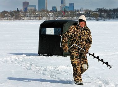
Ice Fishing
Minneapolis lakes offer the same great fishing in the winter as they do in the warmer months. Walleye, Northern Pike and Crappies can be found at Bde Maka Ska.
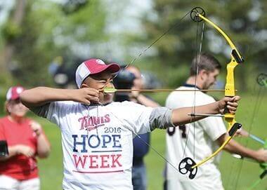
Archery
Practice with a bow and arrow at Bde Maka Ska Park or one of our other archery locations.

Trails in the Winter
They aren't as busy in the winter months, but are maintained as needed so that they remain accessible to pedestrians and bikers.
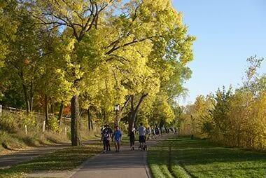
Trails
Bde Maka Ska has 3.1 miles of Pedestrian Trails, and 3.19 miles of Bike Trails encircling the lake.
Trails
Bde Maka Ska has 3.1 miles of Pedestrian Trails, and 3.19 miles of Bike Trails encircling the lake.
Bde Maka Ska
The Dakota name for the lake, "Bde Maka Ska," means White Earth Lake.
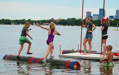
Log Rolling
Log rolling is a sport with strong historical roots in the Midwest, but is new and unique to many. Sessions are offered at Bde Maka Ska Thomas Beach and Lake Nokomis Main Beach.
32nd Street Beach
32nd Street Beach is one of three beaches Bde Maka Ska has to offer, and one of twelve beaches in the Minneapolis park system.
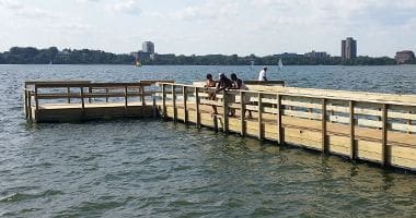
Fishing Pier
Located on West 36th Street and Calhoun Parkway, the pier is a great spot for crappie fishing with slip bobbers, panfish, and Musky

Sailing at Sunset
Have fun learning the basics of sailing through our adult and youth sailing lessons.
Thomas Beach
Thomas Beach is one of three beaches Bde Maka Ska has to offer, and one of twelve beaches in the Minneapolis park system.
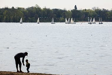
Sailing
Have fun learning the basics of sailing through our adult and youth sailing lessons.
North Beach
North Beach is one of three beaches Bde Maka Ska has to offer, and one of twelve beaches in the Minneapolis park system.

Canals
Chain of Lakes regional park is connected by a series of canals for canoe and kayak.

Winter Wildlife
Even in the winter the lake is full of life!
Park Board Announcements
There are no announcements at this time. Please check back soon.