


Tell us what you think of draft Minnehaha Parkway Regional Trail Master Plan by August 3!
Posted on 19 June, 2020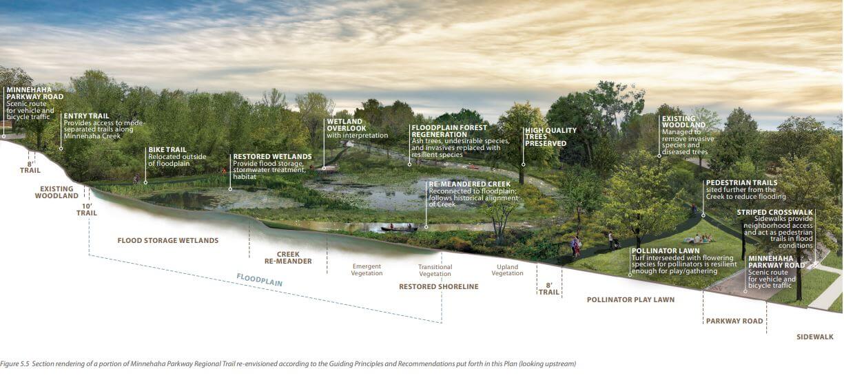
Check out draft master plan for Minnehaha Creek and surrounding parkland and trails in Minneapolis and tell us what you think by August 3!
Today, Friday, June 19, 2020, the Minneapolis Park and Recreation Board (MPRB) published the draft Minnehaha Parkway Regional Trail Master Plan for a 45-day public comment period ending Aug. 3, 2020.
The master plan document is available on the Minnehaha Parkway Regional Trail Master Plan project page and linked below. Comments will be accepted primarily online due to the ongoing COVID-19 pandemic and the current closure of all MPRB recreation centers. Community members can share their thoughts through an online survey or by emailing or calling the project manager listed below.
Draft Master Plan
The Draft Minnehaha Parkway Regional Trail Master Plan is a written and graphic document intended to guide capital improvements in the regional trail area over the next 20-30 years. The master plan document is a direct reflection of the recommendations of an appointed Community Advisory Committee (CAC), which met 12 times between June 2018 and February 2020, and extensive additional community engagement.
1 – Planning Framework [PDF]
2 – Creek History, Background, and Evolution [PDF]
3 – Existing Conditions [PDF]
4 – Input and Community Engagement [PDF]
5 – Master Plan [PDF]
6 – Interpretive Plan [PDF]
7 – Implementation [PDF]
Comment via Online Survey
If you require printed materials, they can be mailed or delivered in a COVID-safe manner. Contact Project Manager Adam Arvidson at 612-230-6470 or aarvidson@minneapolisparks.org to make arrangements.
Plan Highlights
The plan addresses many concerns and ideas discussed by the CAC and community members during nearly two years of community engagement:
Ecology and Water Management
Ecological enhancement, flood mitigation and stormwater management are at the heart of the plan. At full implementation the plan would:
- Add 1.7 miles to the creek’s length within Minneapolis
- Create numerous water-cleansing, habitat-enhancing wetlands and floodplain improvements
- Turn the Lake Harriet tributary into an open, free flowing stream
- Remove enough phosphorous to achieve City of Minneapolis and MPRB responsibility for phosphorous reduction in the Minnehaha Creek and Lake Hiawatha
Bike/Walk Safety
The plan envisions an improved environment for bicyclists and pedestrians while preserving continuous motorized vehicle traffic on the parkway road in both directions. Improvements are focused at key intersections:
- Near Lynnhurst Park
- 50th Street and Portland Avenue
- Minnehaha Parkway and Bloomington Avenue
- Minnehaha Parkway and Cedar Avenue
Recreation Improvements
Increased recreation opportunities are found throughout the plan:
- New canoe/kayak launches (including ADA accessible options)
- A new adventure play area under the Nicollet Avenue bridge
- Bike skills and mountain bike parks near Bloomington Avenue and near 34th Avenue
- A westward extension of bike and pedestrian trails from Lynnhurst Park to Morgan Avenue
Next Steps
- The draft Master Plan public comment period is open until Aug. 3, 2020.
- After the comment period closes, the Master Plan may be modified based on responses received during the comment period.
- A public hearing on the Master Plan will be held at a regular meeting of the Minneapolis Park and Recreation Board of Commissioners, likely this fall.
- The Master Plan will be considered for adoption by the Board of Commissioners
- After the plan is adopted, the MPRB will spend approximately $1 million in the corridor. Specific projects have not yet been determined.