


William Berry Park
Park Hours
6 am-midnight in developed areas
6 am-10 pm in undeveloped areas
Ordinance PB-2-33
William Berry Park
Part of: Minneapolis Chain of Lakes Regional Park
Nearby Recreation Center: Linden Hills Recreation Center
Features & Amenities
- Archery
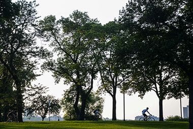
- Biking Path
- Picnic Area
- Playground/Tot Lot
- Walking Path
Not finding what you’re looking for?
Search Parks & Destinations
Good to Know
The William Berry Woods area contains one of the few remnant native plant communities in the Minneapolis park system, relatively untouched since receding glaciers carved out the landscape. See Park Details tab for more information.
Park Projects
See what’s currently in the works for this park. Some projects may be under the name of the regional park or service area it lives within. View Current Projects
Park Details
The William Berry Parkway, which passes through the park, is part of the Grand Rounds Scenic Byway, connecting Lake Harriet Parkway to Lake Calhoun Parkway. Nearby recreation destinations include the tennis courts and picnic grounds of Beard’s Plaisance, and Linden Hills Park.
William Berry Woods
This wooded area contains one of the few remnant native plant communities in the Minneapolis park system, relatively untouched since receding glaciers carved out the landscape.
For many generations before European settlers arrived, the Dakota People lived, hunted, fished, grew their food and gathered medicine throughout this lakes region. The places of their sacred sites and settlements remain. In 1853, surveyor Jesse Jarret described a landscape consisting of tamarack swamp, marshes and rolling terrain with oak and aspen timber and undergrowth. During a trip to Minnesota in the summer of 1861, naturalist Henry David Thoreau and the young Horace Mann, Jr. visited these woods and stayed at a boarding house near the south shore of the lake. Thoreau swam, studied the local flora and fauna, and wrote about the area in his diary, noting that he finally succeeded in finding specimens of the wild crabapple tree.
The natural beauty of this woods has been preserved since it was acquired by the Park Board in 1889 as part of Interlachen Park. In 1916, the park was renamed in honor of William Morse Berry, who served as the first Superintendent of the Minneapolis park system from 1885 to 1906.
Today this woodland is designated as an undeveloped park area for residents and visitors to enjoy. In the spring, look low to the ground for early blooming native wildflowers such as bloodroot, wild ginger and Dutchman’s breeches. As the trees leaf out, look for distinctive Jack-in-the-pulpits, the delicate spray of false Solomon’s seal, and the pink and white blooms of wood anemones. In the fall, look for stands of zig-zag goldenrod and the brilliant berries on baneberry and blue cohosh. The woodland is host to many birds. Watch for commonly seen residents such as chickadees, cardinals, blue jays, nuthatches and hawks. Listen for woodpeckers as they search for insects. Visit during the spring and fall migrations to see and hear many species of warblers.
Rentals & Permits
Outdoor Use and Event Space: Learn how to reserve park space for corporate events, community celebrations, and more.
History
Name: The park is named for William Morse Berry who was the first superintendent of Minneapolis parks. Berry came to Minneapolis in 1884 from Chicago where he had been a park engineer responsible for implementing the park designs of Horace Cleveland in Chicago parks. Cleveland, the visionary landscape architect who provided the first plans for a Minneapolis park system in 1883, and designed many of the city’s early parks, recommended Berry to the park board and also convinced him to take the job. Berry was a native of Maine, like so many of the others who helped create Minneapolis parks, including Charles Loring, George Brackett, Dorilus Morrison and Eloise Butler. Berry remained superintendent of parks until 1906 when he retired and was replaced by Theodore Wirth. Berry managed the growth of Minneapolis parks from practically nothing into a celebrated park system. Berry was described by Charles Loring, the first president of the Minneapolis park board, as “one of Nature’s noblemen.” In the 1900 annual report William Folwell attributed general public approval of the park system “largely to the efficiency and skill” of Berry.
In the annual report of 1905, Berry’s last, he wrote eloquently of his pride in the park system he had helped shape.
“You, gentlemen of the Park Board, are serving the city without financial compensation, yet you have your reward in the satisfaction that your work has exerted an important bearing on the material greatness of Minneapolis, as well as in the enjoyment and uplifting of its people, and which will extend to generations unborn; and while as a salaried officer of this Board, I have received remuneration for my labor, yet, I assure you that I have found, and ever shall feel, that by far the greater and more satisfactory part of my compensation has been in the pleasure I have taken in the reflection that I, too, have had a share in the work.”
The park was first named Interlachen Park in 1890, but was changed to Interlaken Park for a few months in 1893, until the board decided it liked the old spelling better. It kept that name until 1916, when it was renamed to honor Berry’s long service to the city.
The parkway through the park was officially named Shady Lane in 1890. The name of the parkway was not officially changed to William Berry Parkway until 1968.
Acquisition and Development
In November of 1887 the park board appointed a special committee, with board president Charles Loring as the chair, to “consider the advisability” of acquiring land between Lake of the Isles and Lake Calhoun, and between Lake Calhoun and Lake Harriet. By that time the park board had acquired by donation almost all the shores of Lake of the Isles and Lake Harriet and had purchased the eastern shore of Lake Calhoun. It had also acquired land for a boulevard, Linden Hills Parkway, which almost connected Harriet and Calhoun. The special committee was also asked to determine the terms upon which that land could be acquired.
The next summer, the board received a proposal from those who owned land between Calhoun and Harriet to donate land for a parkway “running southerly” from Lake Calhoun. The conditions of their donation must not have been acceptable to the board, because no action was taken on the proposal. Nearly a year later in March 1989, many of the same landowners, led by the Ueland and Dean families, offered again to donate land for a parkway from Calhoun to Harriet under certain conditions. In the early days of the park board, the conditions for land donations usually involved a time period for constructing a parkway or improving the land in some way, and often also exempted the donors from paying assessments on their property for the costs of those improvements. The demand for immediate improvement to the donated land was often the sticking point, because the board often didn’t have the money to spend on improvements. Various offers to donate land for parks throughout the city were turned down because of the board’s lack of funds for improvements and maintenance.
In April 1889 the board directed Superintendent Berry to determine the most feasible route for a parkway connecting the lakes and asked the board’s attorney “to make the best possible bargain for such right of way.” Another special committee was assigned later that summer to consult with land owners to ascertain a price for the land desired. By the fall of 1889, the board directed president Charles Loring to negotiate a price for 24 acres of land and recommended paying the Deans $55,000 and the Uelands $36,000. Loring returned to the board on January 4, 1890 with a deal. For a total of $113,000, payable over ten years without interest, the board acquired the land and assessed the total amount on property in the area. The new park was named Interlachen.
That summer the park board authorized spending $300 to construct a parkway, named Shady Lane, between the lakes. The 1890 annual report of the park board claimed that with the new road it was possible to drive on parkways from Loring Park, out Kenwood Parkway, along all three lakes, and then along Minnehaha Creek all the way to Lyndale Avenue.
The next significant improvement to the park came in 1899 when the park board built a bridge over the street railway tracks between the lakes at a total cost of $11,000 for bridge construction and grading.
The property was then largely ignored for several years except for a brief notice in park proceedings in 1903 that the superintendent should attempt to keep people from dumping rubbish on the property. In Theodore Wirth’s first report as superintendent of parks in 1906, he proposed filling the low ground in the park. This followed the connecting of Shady Lane to Queen Avenue South earlier that year.
The land was partially filled in 1908. Sidewalks were laid along the parkway and trees were planted. Wirth noted in his 1909 report that the pin oaks planted in 1908 were doing so well that he was planting more of them. The first lights were installed along the parkway in 1914, the same year that a bridle path was created through the park.
In 1916 there were press reports that the board was considering building an aquarium at William Berry Park, but official park board proceedings do not mention that project.
William Berry Park was involved in one of the great controversies on the board in the late 1910s, when the park board approved plans to improve the parkway through William Berry Park, create a “south bay” on Lake Calhoun all the way to 42nd Street, and extend Lake Calhoun Parkway around the southern and western shores of the lake.
Area residents objected to the price tag for the improvements, estimated at nearly $700,000, two-thirds of which was to be assessed on area property over twenty years, and filed suit to stop the plan. Residents challenged the board’s legal authority to assess their property for the improvements. Although in 1922 the courts upheld the park board’s power to assess property owners for improvements, the park board had scaled back its development plans by then, eliminating the extension of Lake Calhoun to the south. In 1923, the park board improved the road through William Berry Park as it began the project of developing the southern and western shores of Lake Calhoun.
One of the park’s distinguishing characteristics, its archery range, was established in 1940. Other than that there have been no changes in the basic use of the land.
In 1969-1970 the park board approved the first plans of the Minnesota Transportation Museum to run vintage street cars on the long-unused Como-Harriet street railway track through the park, and in 1977 gave permission to the museum to extend track through the park to the west edge of Lakewood Cemetery.
William Berry Parkway was almost improved in the summer of 1977 when the park board learned that it could get a $700,000 federal grant for the project. But to get the money construction had to begin within 90 days. A Citizens Parkway Committee was assembled to make rapid decisions to take advantage of the funds available. Designs were presented and approved for the new parkway within the allotted time, but the mayor vetoed the project due to neighborhood concerns over the realignment of the road approaching the Lake Harriet pavilion. The park board voted to override the mayor’s veto, but the federal agency that was to provide the funds bowed to public pressure and did not make the grant. Instead the money was used to improve cross-street intersections on Memorial Parkway.
The parkway was eventually paved in 1980. The parkway was ultimately realigned as it approached Lake Harriet, when it was redirected around the new pavilion built at the lake in 1986.
New nature-themed equipment and play areas were installed in 2012.
History through 2008 written by David C. Smith, with updates from 2009 to present written by MPRB.
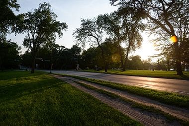
William Berry Parkway
The Grand Rounds Scenic Byway, System allows you to get up close to natural wonders on your bike or on foot.
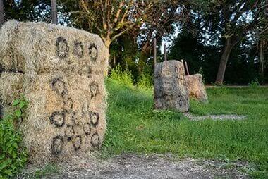
Archery
Practice with a bow and arrow at Wiliam Berry Park or one of our other archery locations.
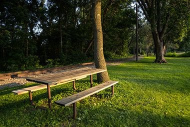
Picnic Area
While the Picnic Areas here are a first-come-first-serve basis, the Park Board has several reservable picnic sites to host your birthday parties and other celebrations.
William Berry Park
The William Berry Parkway, which passes through the park, is part of the Grand Rounds Scenic Byway, connecting Lake Harriet Parkway to Lake Calhoun Parkway.
Park Board Announcements
There are no announcements at this time. Please check back soon.